

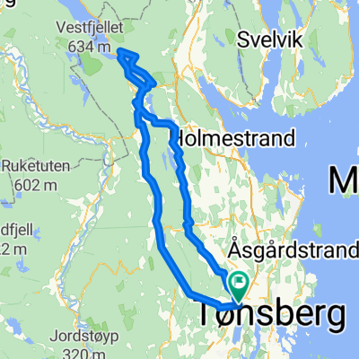
Rute Baglerrunden 2013
A cycling route starting in Sem, Vestfold, Norway.
Overview
About this route
Usual route for the Baglerrunden loop
- -:--
- Duration
- 60.6 km
- Distance
- 420 m
- Ascent
- 425 m
- Descent
- ---
- Avg. speed
- ---
- Max. altitude
Route quality
Waytypes & surfaces along the route
Waytypes
Cycleway
4.9 km
(8 %)
Quiet road
3 km
(5 %)
Surfaces
Paved
43 km
(71 %)
Asphalt
43 km
(71 %)
Undefined
17.6 km
(29 %)
Continue with Bikemap
Use, edit, or download this cycling route
You would like to ride Rute Baglerrunden 2013 or customize it for your own trip? Here is what you can do with this Bikemap route:
Free features
- Save this route as favorite or in collections
- Copy & plan your own version of this route
- Sync your route with Garmin or Wahoo
Premium features
Free trial for 3 days, or one-time payment. More about Bikemap Premium.
- Navigate this route on iOS & Android
- Export a GPX / KML file of this route
- Create your custom printout (try it for free)
- Download this route for offline navigation
Discover more Premium features.
Get Bikemap PremiumFrom our community
Other popular routes starting in Sem
 SuperBaglern
- Distance
- 112.1 km
- Ascent
- 625 m
- Descent
- 630 m
- Location
- Sem, Vestfold, Norway
 Super Baglern
- Distance
- 62.4 km
- Ascent
- 402 m
- Descent
- 408 m
- Location
- Sem, Vestfold, Norway
 Super Bagler
- Distance
- 93 km
- Ascent
- 498 m
- Descent
- 502 m
- Location
- Sem, Vestfold, Norway
 Sem - Eidsfoss - Sem
- Distance
- 99.3 km
- Ascent
- 437 m
- Descent
- 435 m
- Location
- Sem, Vestfold, Norway
 Rute Baglerrunden 2013
- Distance
- 60.6 km
- Ascent
- 420 m
- Descent
- 425 m
- Location
- Sem, Vestfold, Norway
 Bagler 2014
- Distance
- 69.2 km
- Ascent
- 479 m
- Descent
- 482 m
- Location
- Sem, Vestfold, Norway
 Dokka Rundt
- Distance
- 83.1 km
- Ascent
- 344 m
- Descent
- 345 m
- Location
- Sem, Vestfold, Norway
 Dokka Rundt
- Distance
- 89.8 km
- Ascent
- 421 m
- Descent
- 421 m
- Location
- Sem, Vestfold, Norway
Open it in the app