

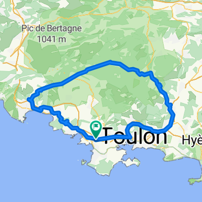
14.1_Le Brusc > Signes (par Col de Garde)
A cycling route starting in Sanary-sur-Mer, Provence-Alpes-Côte d'Azur Region, France.
Overview
About this route
Bandol
Sanary
Le Brusq
Corniche du Mai
Tamaris
Le Col de Garde
St Anne d'Evennos
Le Beausset
Bandol
- -:--
- Duration
- 62.6 km
- Distance
- 943 m
- Ascent
- 603 m
- Descent
- ---
- Avg. speed
- ---
- Max. altitude
Route quality
Waytypes & surfaces along the route
Waytypes
Road
21.3 km
(34 %)
Quiet road
6.9 km
(11 %)
Surfaces
Paved
28.2 km
(45 %)
Asphalt
28.2 km
(45 %)
Undefined
34.4 km
(55 %)
Continue with Bikemap
Use, edit, or download this cycling route
You would like to ride 14.1_Le Brusc > Signes (par Col de Garde) or customize it for your own trip? Here is what you can do with this Bikemap route:
Free features
- Save this route as favorite or in collections
- Copy & plan your own version of this route
- Sync your route with Garmin or Wahoo
Premium features
Free trial for 3 days, or one-time payment. More about Bikemap Premium.
- Navigate this route on iOS & Android
- Export a GPX / KML file of this route
- Create your custom printout (try it for free)
- Download this route for offline navigation
Discover more Premium features.
Get Bikemap PremiumFrom our community
Other popular routes starting in Sanary-sur-Mer
 grand tour du camp CLONED FROM ROUTE 360637
- Distance
- 105.4 km
- Ascent
- 1,056 m
- Descent
- 1,056 m
- Location
- Sanary-sur-Mer, Provence-Alpes-Côte d'Azur Region, France
 Sanary-Le Coudon
- Distance
- 26.2 km
- Ascent
- 764 m
- Descent
- 86 m
- Location
- Sanary-sur-Mer, Provence-Alpes-Côte d'Azur Region, France
 21 mai 2022 le Brusc
- Distance
- 30.8 km
- Ascent
- 278 m
- Descent
- 274 m
- Location
- Sanary-sur-Mer, Provence-Alpes-Côte d'Azur Region, France
 grand tour du camp
- Distance
- 105.2 km
- Ascent
- 1,261 m
- Descent
- 1,174 m
- Location
- Sanary-sur-Mer, Provence-Alpes-Côte d'Azur Region, France
 Brevet 150 SCS 2014
- Distance
- 158.4 km
- Ascent
- 1,734 m
- Descent
- 1,730 m
- Location
- Sanary-sur-Mer, Provence-Alpes-Côte d'Azur Region, France
 Von Six-Fours-020625
- Distance
- 15.9 km
- Ascent
- 393 m
- Descent
- 385 m
- Location
- Sanary-sur-Mer, Provence-Alpes-Côte d'Azur Region, France
 DAY1 SSM to Hyeres
- Distance
- 43.3 km
- Ascent
- 252 m
- Descent
- 275 m
- Location
- Sanary-sur-Mer, Provence-Alpes-Côte d'Azur Region, France
 Hyères - Sainte-Maxime
- Distance
- 89.1 km
- Ascent
- 909 m
- Descent
- 919 m
- Location
- Sanary-sur-Mer, Provence-Alpes-Côte d'Azur Region, France
Open it in the app