GARRIGA - Pego/ValldEbo/Tollos/Balones/Benimarfull/Planes -
- 87 km
- 1,241 m
- 1,244 m
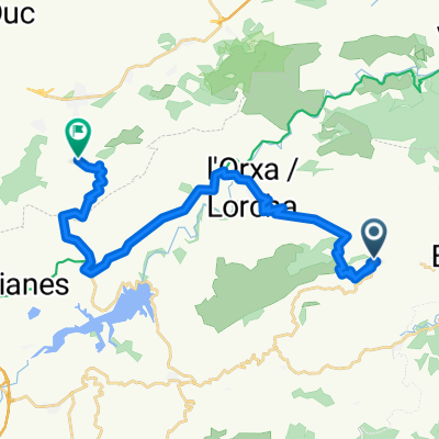
- Vall de Gallinera, Valencia, Spain
A cycling route starting in Vall de Gallinera, Valencia, Spain.
Overview
After Vall d'Ebo, the next municipality will be 'Alcalá de la Jovada' (CV-712). After a few kilometers, we will leave the CV-712 and take the CV-713 (on the left) heading towards 'Beniaia' and 'Tollos'. A few kilometers after 'Tollos', we will take the CV-720 towards 'Benimassot' and 'Balones'. Upon reaching 'Gorga', we will arrive at a junction where we will take the CV-710 towards 'Millena', continue on this road towards 'Benillup', then take the CV-704 towards 'Benimarfull', and then on to Planes and Patró.
created this 12 years ago
Route quality
Road
8.7 km
(10 %)
Quiet road
0.9 km
(1 %)
Undefined
77.5 km
(89 %)
Paved
70.5 km
(81 %)
Asphalt
70.5 km
(81 %)
Undefined
16.5 km
(19 %)
Continue with Bikemap
You would like to ride GARRIGA - Pego/ValldEbo/Tollos/Balones/Benimarfull/Planes - or customize it for your own trip? Here is what you can do with this Bikemap route:
Free trial for 3 days, or one-time payment. More about Bikemap Premium.
Discover more Premium features.
Get Bikemap PremiumFrom our community
Open it in the app