Venta El Papero,Sierra Grande,Villarbajo,rizo en Alcaudete,v. verde,Martos.
A cycling route starting in Martos, Andalusia, Spain.
Overview
About this route
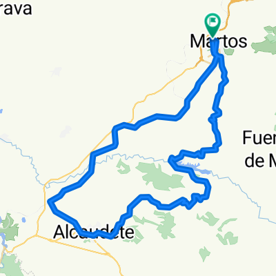
The route itinerary is as follows: we leave Martos and head towards Fuensanta, taking a detour past the Cazalla olive mill, reaching the Venta El Papero, and continue to Los Llanillos. We carry on and turn right to descend to the Villarbajo chapel, then climb back up towards Alcaudete. Take another right to ascend through Moraledas Altas, crest at Cortijo El Portillo, descend into Alcaudete, and continue to the train station. From there, we head to Martos via the Via Verde, then take a rural track that brings us back to Alcaudete near the funeral home, making a loop in the stage. We then return up the road and enter the Fuente Amuña path, descending directly to the Víboras viaduct on the Via Verde before continuing to Martos. The route features local roads, rural tracks, and the Via Verde. It can be ridden a few hours after rainfall, includes good ramps, descents, and very fast pedalling sections, and passes through olive groves and some stretches of Mediterranean woodland.
- -:--
- Duration
- 75.2 km
- Distance
- 1,392 m
- Ascent
- 1,409 m
- Descent
- ---
- Avg. speed
- ---
- Max. altitude
Route quality
Waytypes & surfaces along the route
Waytypes
Cycleway
24.1 km
(32 %)
Road
20.3 km
(27 %)
Surfaces
Paved
11.3 km
(15 %)
Unpaved
2.3 km
(3 %)
Asphalt
9 km
(12 %)
Paved (undefined)
2.3 km
(3 %)
Continue with Bikemap
Use, edit, or download this cycling route
You would like to ride Venta El Papero,Sierra Grande,Villarbajo,rizo en Alcaudete,v. verde,Martos. or customize it for your own trip? Here is what you can do with this Bikemap route:
Free features
- Save this route as favorite or in collections
- Copy & plan your own version of this route
- Sync your route with Garmin or Wahoo
Premium features
Free trial for 3 days, or one-time payment. More about Bikemap Premium.
- Navigate this route on iOS & Android
- Export a GPX / KML file of this route
- Create your custom printout (try it for free)
- Download this route for offline navigation
Discover more Premium features.
Get Bikemap PremiumFrom our community
Other popular routes starting in Martos
- LasCHORRERAS
- Distance
- 65.2 km
- Ascent
- 1,224 m
- Descent
- 1,223 m
- Location
- Martos, Andalusia, Spain
- La mella,Fuente el palo,solana de Jabalcuz,La Grana,Martos
- Distance
- 58.9 km
- Ascent
- 1,149 m
- Descent
- 1,140 m
- Location
- Martos, Andalusia, Spain
- Alcaudete por carretera vieja,Portillo,presa Viboras,Casillas,Carrasca,Martos
- Distance
- 57.9 km
- Ascent
- 1,020 m
- Descent
- 1,020 m
- Location
- Martos, Andalusia, Spain
- Sierra Ahillos por fuente amuña,presa viboras,Martos por el Alamillo
- Distance
- 59.9 km
- Ascent
- 1,226 m
- Descent
- 1,226 m
- Location
- Martos, Andalusia, Spain
- El Madroño,El Coracho,Las Peñuelas,Las Aceras,Lendinez,Martos
- Distance
- 43.9 km
- Ascent
- 557 m
- Descent
- 557 m
- Location
- Martos, Andalusia, Spain
- Venta el papero,Fuente el espino,presa Viboras,Martos
- Distance
- 43.8 km
- Ascent
- 894 m
- Descent
- 873 m
- Location
- Martos, Andalusia, Spain
- SIERRA SUR de JAÉN
- Distance
- 89.9 km
- Ascent
- 1,342 m
- Descent
- 1,352 m
- Location
- Martos, Andalusia, Spain
- Camino del Moro,La Grana,Marchante,Cresta,Jamilena,Via verde,Martos
- Distance
- 29.8 km
- Ascent
- 731 m
- Descent
- 733 m
- Location
- Martos, Andalusia, Spain
Open it in the app