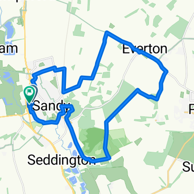
Short Timed Route Out of Sandy
A cycling route starting in Sandy, England, United Kingdom.
Overview
About this route
Short test route around Sandy...
- -:--
- Duration
- 13.3 km
- Distance
- 80 m
- Ascent
- 65 m
- Descent
- ---
- Avg. speed
- 77 m
- Max. altitude
Route quality
Waytypes & surfaces along the route
Waytypes
Cycleway
4.4 km
(33 %)
Quiet road
3.6 km
(27 %)
Surfaces
Paved
5.1 km
(38 %)
Unpaved
2.5 km
(19 %)
Asphalt
3.2 km
(24 %)
Ground
2.1 km
(16 %)
Continue with Bikemap
Use, edit, or download this cycling route
You would like to ride Short Timed Route Out of Sandy or customize it for your own trip? Here is what you can do with this Bikemap route:
Free features
- Save this route as favorite or in collections
- Copy & plan your own version of this route
- Sync your route with Garmin or Wahoo
Premium features
Free trial for 3 days, or one-time payment. More about Bikemap Premium.
- Navigate this route on iOS & Android
- Export a GPX / KML file of this route
- Create your custom printout (try it for free)
- Download this route for offline navigation
Discover more Premium features.
Get Bikemap PremiumFrom our community
Other popular routes starting in Sandy
Sandy to Ampthill....- Distance
- 21.7 km
- Ascent
- 168 m
- Descent
- 105 m
- Location
- Sandy, England, United Kingdom
Greensand, Gravel and Great Ouse- Distance
- 60.7 km
- Ascent
- 279 m
- Descent
- 277 m
- Location
- Sandy, England, United Kingdom
RSPB TO RSPB Anti clockwise- Distance
- 5.2 km
- Ascent
- 73 m
- Descent
- 74 m
- Location
- Sandy, England, United Kingdom
Short Timed Route Out of Sandy- Distance
- 13.3 km
- Ascent
- 80 m
- Descent
- 65 m
- Location
- Sandy, England, United Kingdom
To St. Neots- Distance
- 29 km
- Ascent
- 67 m
- Descent
- 66 m
- Location
- Sandy, England, United Kingdom
RSPB to Cople Road 316, Cardington- Distance
- 18.1 km
- Ascent
- 28 m
- Descent
- 75 m
- Location
- Sandy, England, United Kingdom
Out to Moggerhanger- Distance
- 13.5 km
- Ascent
- 40 m
- Descent
- 39 m
- Location
- Sandy, England, United Kingdom
South of Biggleswade Loop- Distance
- 47.9 km
- Ascent
- 181 m
- Descent
- 163 m
- Location
- Sandy, England, United Kingdom
Open it in the app

