
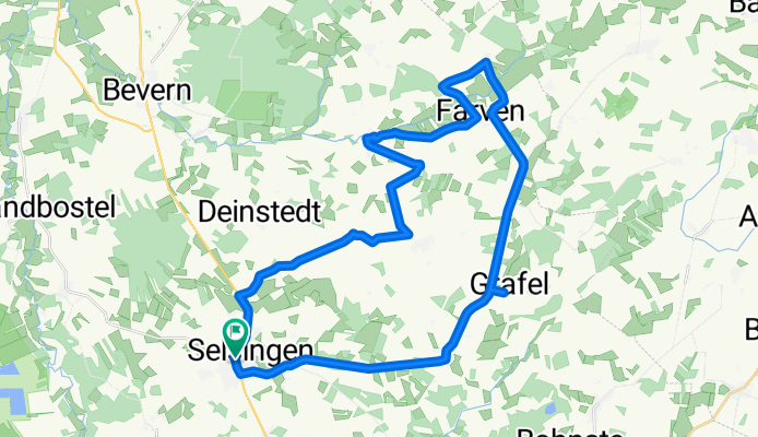
Selsinger Landpartie – Die Nutztierroute 1 (Duxbach-Route)
A cycling route starting in Selsingen, Lower Saxony, Germany.
Overview
About this route
<span class="richtext">Die Selsinger Landpartie "Nutztierroute" führt Sie durch eine abwechslungsreiche Landschaft und vorbei an den heimischen Hoftieren rund um Selsingen, wobei Sie einiges über die Region erfahren. Neben traditionell heimischen Tieren wie Kühen, Schweinen und Islandpferden, können Sie auf dieser Route auch selten gewordene Nutztiere auf den Weiden und in den Ställen der Landwirte bestaunen.</span>
- -:--
- Duration
- 34.1 km
- Distance
- 92 m
- Ascent
- 92 m
- Descent
- ---
- Avg. speed
- ---
- Max. altitude

Route quality
Waytypes & surfaces along the route
Waytypes
Road
17.9 km
(53 %)
Quiet road
9.8 km
(29 %)
Surfaces
Paved
10.9 km
(32 %)
Unpaved
1.4 km
(4 %)
Asphalt
10.6 km
(31 %)
Gravel
1.4 km
(4 %)
Continue with Bikemap
Use, edit, or download this cycling route
You would like to ride Selsinger Landpartie – Die Nutztierroute 1 (Duxbach-Route) or customize it for your own trip? Here is what you can do with this Bikemap route:
Free features
- Save this route as favorite or in collections
- Copy & plan your own version of this route
- Sync your route with Garmin or Wahoo
Premium features
Free trial for 3 days, or one-time payment. More about Bikemap Premium.
- Navigate this route on iOS & Android
- Export a GPX / KML file of this route
- Create your custom printout (try it for free)
- Download this route for offline navigation
Discover more Premium features.
Get Bikemap PremiumFrom our community
Other popular routes starting in Selsingen
 Selsingen - Otterndorf
- Distance
- 148.6 km
- Ascent
- 277 m
- Descent
- 289 m
- Location
- Selsingen, Lower Saxony, Germany
 Parnewinkler Dorfstraße 10, Selsingen nach Parnewinkler Dorfstraße 1, Selsingen
- Distance
- 4.9 km
- Ascent
- 4 m
- Descent
- 52 m
- Location
- Selsingen, Lower Saxony, Germany
 Am Mühlenberg 6a, Selsingen nach Am Mühlenberg 6a, Selsingen
- Distance
- 6.9 km
- Ascent
- 22 m
- Descent
- 68 m
- Location
- Selsingen, Lower Saxony, Germany
 Am Mühlenberg 6a, Selsingen nach Am Mühlenberg 6a, Selsingen
- Distance
- 6.7 km
- Ascent
- 20 m
- Descent
- 21 m
- Location
- Selsingen, Lower Saxony, Germany
 Tour Nieder-Ochtenhausen
- Distance
- 67.4 km
- Ascent
- 92 m
- Descent
- 95 m
- Location
- Selsingen, Lower Saxony, Germany
 Selsingen, Anderlingen, Heeslingen, Boitzen, Weertzen, Bohnste, Ohrel
- Distance
- 43.1 km
- Ascent
- 109 m
- Descent
- 108 m
- Location
- Selsingen, Lower Saxony, Germany
 Selsingen, Sandbostel, Gnarrenburg
- Distance
- 43.1 km
- Ascent
- 33 m
- Descent
- 33 m
- Location
- Selsingen, Lower Saxony, Germany
 Tour Oldendorf
- Distance
- 50.9 km
- Ascent
- 137 m
- Descent
- 136 m
- Location
- Selsingen, Lower Saxony, Germany
Open it in the app