

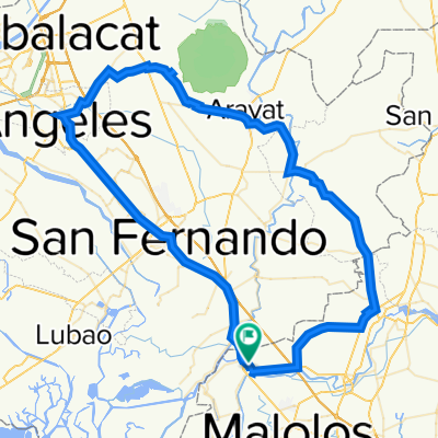
Gatbuca Calumpit - Mount Balabac Norzagaray
A cycling route starting in Calumpit, Central Luzon, Philippines.
Overview
About this route
Gatbuca Calumpit - Mount Balabac Norzagaray
- -:--
- Duration
- 135.6 km
- Distance
- 762 m
- Ascent
- 761 m
- Descent
- ---
- Avg. speed
- ---
- Max. altitude

Continue with Bikemap
Use, edit, or download this cycling route
You would like to ride Gatbuca Calumpit - Mount Balabac Norzagaray or customize it for your own trip? Here is what you can do with this Bikemap route:
Free features
- Save this route as favorite or in collections
- Copy & plan your own version of this route
- Split it into stages to create a multi-day tour
- Sync your route with Garmin or Wahoo
Premium features
Free trial for 3 days, or one-time payment. More about Bikemap Premium.
- Navigate this route on iOS & Android
- Export a GPX / KML file of this route
- Create your custom printout (try it for free)
- Download this route for offline navigation
Discover more Premium features.
Get Bikemap PremiumFrom our community
Other popular routes starting in Calumpit
 Calumpit to Calumpit
- Distance
- 33.8 km
- Ascent
- 93 m
- Descent
- 84 m
- Location
- Calumpit, Central Luzon, Philippines
 Tara na sa GARAY!
- Distance
- 88.1 km
- Ascent
- 96 m
- Descent
- 99 m
- Location
- Calumpit, Central Luzon, Philippines
 Calumpit to Provincial Road 90, Calumpit
- Distance
- 58.3 km
- Ascent
- 47 m
- Descent
- 47 m
- Location
- Calumpit, Central Luzon, Philippines
 WQ6F+46M, Calumpit to WQ6F+46M, Calumpit
- Distance
- 110.7 km
- Ascent
- 176 m
- Descent
- 176 m
- Location
- Calumpit, Central Luzon, Philippines
 Poblacion-Calizon-Caniogan Loop
- Distance
- 6.8 km
- Ascent
- 8 m
- Descent
- 4 m
- Location
- Calumpit, Central Luzon, Philippines
 orlac mountain bike
- Distance
- 136.4 km
- Ascent
- 122 m
- Descent
- 122 m
- Location
- Calumpit, Central Luzon, Philippines
 Unnamed Road, Calumpit to San Felipe
- Distance
- 119.8 km
- Ascent
- 1,080 m
- Descent
- 1,089 m
- Location
- Calumpit, Central Luzon, Philippines
 MacArthur Highway, Calumpit to Roxas Boulevard, Maynila
- Distance
- 52.6 km
- Ascent
- 1,557 m
- Descent
- 1,577 m
- Location
- Calumpit, Central Luzon, Philippines
Open it in the app