

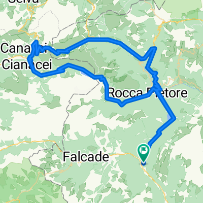
Dolomitas 2013 (Cencenighe)
A cycling route starting in Cencenighe Agordino, Veneto, Italy.
Overview
About this route
- -:--
- Duration
- 121.8 km
- Distance
- 3,077 m
- Ascent
- 3,077 m
- Descent
- ---
- Avg. speed
- ---
- Max. altitude
Route quality
Waytypes & surfaces along the route
Waytypes
Quiet road
2.4 km
(2 %)
Access road
1.2 km
(1 %)
Surfaces
Paved
101.1 km
(83 %)
Asphalt
80.4 km
(66 %)
Paved (undefined)
20.7 km
(17 %)
Undefined
20.7 km
(17 %)
Continue with Bikemap
Use, edit, or download this cycling route
You would like to ride Dolomitas 2013 (Cencenighe) or customize it for your own trip? Here is what you can do with this Bikemap route:
Free features
- Save this route as favorite or in collections
- Copy & plan your own version of this route
- Split it into stages to create a multi-day tour
- Sync your route with Garmin or Wahoo
Premium features
Free trial for 3 days, or one-time payment. More about Bikemap Premium.
- Navigate this route on iOS & Android
- Export a GPX / KML file of this route
- Create your custom printout (try it for free)
- Download this route for offline navigation
Discover more Premium features.
Get Bikemap PremiumFrom our community
Other popular routes starting in Cencenighe Agordino
 Vytoceni nohou
- Distance
- 116.1 km
- Ascent
- 2,889 m
- Descent
- 2,889 m
- Location
- Cencenighe Agordino, Veneto, Italy
 HAUTE ROUTE DOLOMITES Day 5
- Distance
- 135 km
- Ascent
- 396 m
- Descent
- 1,166 m
- Location
- Cencenighe Agordino, Veneto, Italy
 Da Statale 203, Cencenighe Agordino a Piazza Municipio 10, Falcade
- Distance
- 9.2 km
- Ascent
- 487 m
- Descent
- 146 m
- Location
- Cencenighe Agordino, Veneto, Italy
 Cencenighe - Passo Fedaia - Passo Pordoi - Cencenighe
- Distance
- 96 km
- Ascent
- 2,137 m
- Descent
- 2,137 m
- Location
- Cencenighe Agordino, Veneto, Italy
 Belluno Dolomitak - Cencenigue Agordino - Arabba
- Distance
- 159.3 km
- Ascent
- 4,923 m
- Descent
- 4,095 m
- Location
- Cencenighe Agordino, Veneto, Italy
 Cencenighe - Agordo defaticamento
- Distance
- 32.3 km
- Ascent
- 422 m
- Descent
- 422 m
- Location
- Cencenighe Agordino, Veneto, Italy
 Cencenighe - Caprile - San Tomaso - Cencenighe
- Distance
- 40.4 km
- Ascent
- 635 m
- Descent
- 636 m
- Location
- Cencenighe Agordino, Veneto, Italy
 Borghi Falcade
- Distance
- 43.4 km
- Ascent
- 1,756 m
- Descent
- 1,761 m
- Location
- Cencenighe Agordino, Veneto, Italy
Open it in the app