

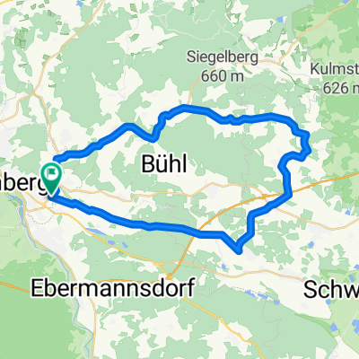
Besuch beim "Alten Fritz"
A cycling route starting in Amberg, Bavaria, Germany.
Overview
About this route
The route leads from Amberg to the far west of the Amberg-Sulzbach district, into the valleys of Högenbach and Etzelbach. The return route partly follows the Five Rivers Cycle Path. The starting point is the junction of Fleury Street with Kaiser-Wilhelm-Ring. From Speckmannshof, the route mostly follows the marked cycle path No. 8. From Weigendorf to Kauerhof, the route follows the Five Rivers Cycle Path but then bypasses the urban area of Sulzbach-Rosenberg extensively through the forested areas of Oberen and Unteren Wagensaß and the Breitenbrunn valley with its impressive rock walls. In Rosenberg, the route passes through the industrial area near Unterschwaig and then leads through forest and farmland to Altmannshof. At Witzlhof, the route reconnects with the Five Rivers Cycle Path, which it follows to the endpoint at Maxplatz.
Places to eat and drink:
- Aichazandt: Gasthaus Schmidt
- Högen: Gasthaus zum Schloss
- Haunritz: Gasthaus 'Zum Alten Fritz'
- Öd: Gasthaus 'Zur Traube' (also known as 'Bayerischer Johann')
- Neukirchen bei Sulzbach-Rosenberg: Gasthaus 'Neukirchener Hof'
- Kauerhof: Gasthaus 'Zum Wulfen'
- Breitenbrunn: Gasthaus 'Zum Rieglesbrunnen'
- Altmannshof: Gasthaus Kopf
Scenic highlights:
- Högenbach valley with 'Altem Fritz', a rock tower reminiscent in shape of the Prussian King Frederick the Great.
- Etzelbach valley between Öd and Etzelwang
- Breitenbrunn valley with vertical rock walls
- -:--
- Duration
- 59.4 km
- Distance
- 424 m
- Ascent
- 433 m
- Descent
- ---
- Avg. speed
- ---
- Max. altitude

Route quality
Waytypes & surfaces along the route
Waytypes
Quiet road
27.9 km
(47 %)
Track
14.8 km
(25 %)
Surfaces
Paved
39.8 km
(67 %)
Unpaved
13.7 km
(23 %)
Asphalt
38 km
(64 %)
Gravel
11.9 km
(20 %)
Continue with Bikemap
Use, edit, or download this cycling route
You would like to ride Besuch beim "Alten Fritz" or customize it for your own trip? Here is what you can do with this Bikemap route:
Free features
- Save this route as favorite or in collections
- Copy & plan your own version of this route
- Sync your route with Garmin or Wahoo
Premium features
Free trial for 3 days, or one-time payment. More about Bikemap Premium.
- Navigate this route on iOS & Android
- Export a GPX / KML file of this route
- Create your custom printout (try it for free)
- Download this route for offline navigation
Discover more Premium features.
Get Bikemap PremiumFrom our community
Other popular routes starting in Amberg
 Amberg to Dollackerstraße, Amberg
- Distance
- 8.9 km
- Ascent
- 73 m
- Descent
- 76 m
- Location
- Amberg, Bavaria, Germany
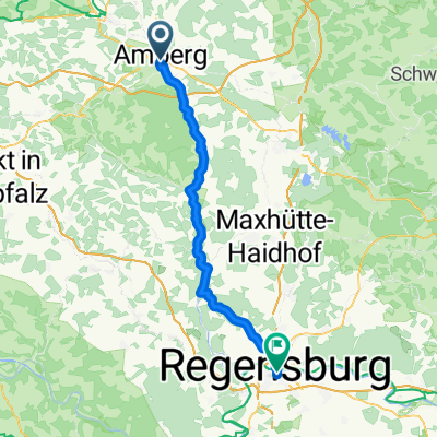 N2 - Amberg - Regensburg
- Distance
- 64.3 km
- Ascent
- 962 m
- Descent
- 997 m
- Location
- Amberg, Bavaria, Germany
 Citytriathlon Amberg - CTA 2011 - 10km Runde
- Distance
- 10.6 km
- Ascent
- 87 m
- Descent
- 89 m
- Location
- Amberg, Bavaria, Germany
 Teil_1_Amberg-Kallmünz
- Distance
- 38.9 km
- Ascent
- 168 m
- Descent
- 202 m
- Location
- Amberg, Bavaria, Germany
 Raigeringer Dorfstraße do Raigeringer Dorfstraße
- Distance
- 31.9 km
- Ascent
- 371 m
- Descent
- 371 m
- Location
- Amberg, Bavaria, Germany
 die H2-Schikane
- Distance
- 39.1 km
- Ascent
- 480 m
- Descent
- 480 m
- Location
- Amberg, Bavaria, Germany
 Die H1-Schikane
- Distance
- 40.6 km
- Ascent
- 449 m
- Descent
- 449 m
- Location
- Amberg, Bavaria, Germany
 Amberg - Regensburg
- Distance
- 70.3 km
- Ascent
- 250 m
- Descent
- 273 m
- Location
- Amberg, Bavaria, Germany
Open it in the app