

Ostertour I
A cycling route starting in Einsiedeln, Canton of Schwyz, Switzerland.
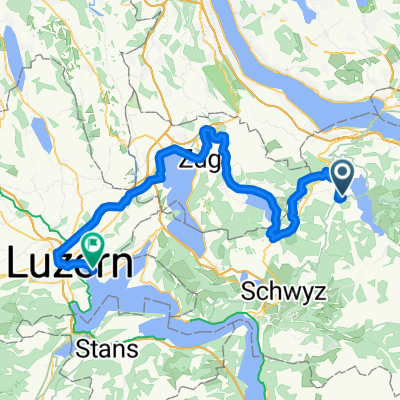
Overview
About this route
Gross - St. Gallen in heavy snowfall
31.03.2013
- -:--
- Duration
- 84.5 km
- Distance
- 905 m
- Ascent
- 1,147 m
- Descent
- ---
- Avg. speed
- ---
- Max. altitude

Route quality
Waytypes & surfaces along the route
Waytypes
Quiet road
10.1 km
(12 %)
Cycleway
10.1 km
(12 %)
Surfaces
Paved
75.2 km
(89 %)
Unpaved
0.8 km
(1 %)
Asphalt
73.6 km
(87 %)
Paved (undefined)
1.7 km
(2 %)
Continue with Bikemap
Use, edit, or download this cycling route
You would like to ride Ostertour I or customize it for your own trip? Here is what you can do with this Bikemap route:
Free features
- Save this route as favorite or in collections
- Copy & plan your own version of this route
- Split it into stages to create a multi-day tour
- Sync your route with Garmin or Wahoo
Premium features
Free trial for 3 days, or one-time payment. More about Bikemap Premium.
- Navigate this route on iOS & Android
- Export a GPX / KML file of this route
- Create your custom printout (try it for free)
- Download this route for offline navigation
Discover more Premium features.
Get Bikemap PremiumFrom our community
Other popular routes starting in Einsiedeln
 Rigi+
Rigi+- Distance
- 103 km
- Ascent
- 1,317 m
- Descent
- 1,317 m
- Location
- Einsiedeln, Canton of Schwyz, Switzerland
 SoTo 2018/7: Einsiedeln - Luzern
- Distance
- 79 km
- Ascent
- 215 m
- Descent
- 676 m
- Location
- Einsiedeln, Canton of Schwyz, Switzerland
 Falscher Weg ins Stöcklichrüz
- Distance
- 21.4 km
- Ascent
- 509 m
- Descent
- 506 m
- Location
- Einsiedeln, Canton of Schwyz, Switzerland
 Hoch Ybrig Runde
- Distance
- 46.7 km
- Ascent
- 1,046 m
- Descent
- 1,048 m
- Location
- Einsiedeln, Canton of Schwyz, Switzerland
 Sihlsee - Stöcklichrüz - Meinrad
- Distance
- 19.2 km
- Ascent
- 614 m
- Descent
- 593 m
- Location
- Einsiedeln, Canton of Schwyz, Switzerland
 Haggenegg - Ibergeregg
- Distance
- 52.5 km
- Ascent
- 1,341 m
- Descent
- 1,342 m
- Location
- Einsiedeln, Canton of Schwyz, Switzerland
 Hoch Ybrig Runde
- Distance
- 46.7 km
- Ascent
- 1,022 m
- Descent
- 1,027 m
- Location
- Einsiedeln, Canton of Schwyz, Switzerland
 Hummelroute
- Distance
- 37.8 km
- Ascent
- 796 m
- Descent
- 808 m
- Location
- Einsiedeln, Canton of Schwyz, Switzerland
Open it in the app