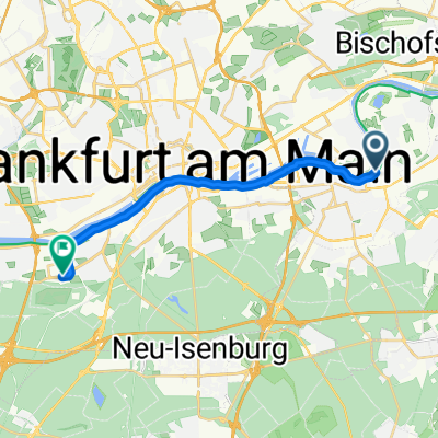
2013_3. Etappe F - F/Bergen Enkheim
A cycling route starting in Offenbach, Hesse, Germany.
Overview
About this route
Differences in kilometer indications are due to varying map materials
- -:--
- Duration
- 100.6 km
- Distance
- 491 m
- Ascent
- 423 m
- Descent
- ---
- Avg. speed
- ---
- Max. altitude
Route quality
Waytypes & surfaces along the route
Waytypes
Road
25.1 km
(25 %)
Quiet road
9.1 km
(9 %)
Surfaces
Paved
93.5 km
(93 %)
Unpaved
1 km
(1 %)
Asphalt
93.5 km
(93 %)
Ground
1 km
(1 %)
Undefined
6 km
(6 %)
Route highlights
Points of interest along the route
Point of interest after 34.1 km
Sprintwertung
Photo after 57.7 km
Bergwertung Kat. 3
Point of interest after 72.7 km
Sprintwertung
Photo after 100.6 km
Ziel / Bergwertung Kat. 2
Continue with Bikemap
Use, edit, or download this cycling route
You would like to ride 2013_3. Etappe F - F/Bergen Enkheim or customize it for your own trip? Here is what you can do with this Bikemap route:
Free features
- Save this route as favorite or in collections
- Copy & plan your own version of this route
- Split it into stages to create a multi-day tour
- Sync your route with Garmin or Wahoo
Premium features
Free trial for 3 days, or one-time payment. More about Bikemap Premium.
- Navigate this route on iOS & Android
- Export a GPX / KML file of this route
- Create your custom printout (try it for free)
- Download this route for offline navigation
Discover more Premium features.
Get Bikemap PremiumFrom our community
Other popular routes starting in Offenbach
- MTB Neuhof Variante CLONED FROM ROUTE 121663
- Distance
- 27 km
- Ascent
- 100 m
- Descent
- 97 m
- Location
- Offenbach, Hesse, Germany
- Goetheturmfahrt
- Distance
- 18.5 km
- Ascent
- 85 m
- Descent
- 92 m
- Location
- Offenbach, Hesse, Germany
- Borsigallee, Frankfurt am Main nach An der Winkelsmühle, Dreieich
- Distance
- 19.8 km
- Ascent
- 151 m
- Descent
- 95 m
- Location
- Offenbach, Hesse, Germany
- Rhein-Main-Runde
- Distance
- 158.2 km
- Ascent
- 522 m
- Descent
- 521 m
- Location
- Offenbach, Hesse, Germany
- Wetterau Rennrad
- Distance
- 48.3 km
- Ascent
- 175 m
- Descent
- 175 m
- Location
- Offenbach, Hesse, Germany
- Von Park zu Park in Offenbach
- Distance
- 17.6 km
- Ascent
- 108 m
- Descent
- 108 m
- Location
- Offenbach, Hesse, Germany
- OF-Götzemhain-Dietzenbach-Rodgau-OF
- Distance
- 37.4 km
- Ascent
- 123 m
- Descent
- 110 m
- Location
- Offenbach, Hesse, Germany
- 08 - Maintal Schlösser und Parks
- Distance
- 24.7 km
- Ascent
- 66 m
- Descent
- 64 m
- Location
- Offenbach, Hesse, Germany
Open it in the app