

Limestone Mt. Loop
A cycling route starting in Parsons, West Virginia, United States.
Overview
About this route
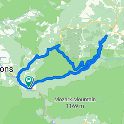
One long climb up Location Road, rolling across Limestone Mountain and then you descend back to the river at St. George. Don't let the first steep ramp out of St. George scare you. The climb is mostly 5-7% for the first 5 miles, then a little down grade the the last couple miles you have some 8-10% grades.
0.0 Start at the park by the river in St. George. Leaving the park you continue straight thru St. George and begin an immediate climb on Cty 5, Location Road.<br />
9.0 Left on Cty. 3.
13.0 Bare left. to stay on Limestone Rd. <br />
13.2 Cty. 3 right right. Stay straight to continue on what is now Cty. 1.
20.6 Right in St. George to return to Park.
20.8 Finish<br />
- -:--
- Duration
- 33.4 km
- Distance
- 587 m
- Ascent
- 587 m
- Descent
- ---
- Avg. speed
- ---
- Max. altitude

Route quality
Waytypes & surfaces along the route
Waytypes
Quiet road
18.1 km
(54 %)
Road
15.3 km
(46 %)
Surfaces
Unpaved
6 km
(18 %)
Gravel
6 km
(18 %)
Undefined
27.4 km
(82 %)
Continue with Bikemap
Use, edit, or download this cycling route
You would like to ride Limestone Mt. Loop or customize it for your own trip? Here is what you can do with this Bikemap route:
Free features
- Save this route as favorite or in collections
- Copy & plan your own version of this route
- Sync your route with Garmin or Wahoo
Premium features
Free trial for 3 days, or one-time payment. More about Bikemap Premium.
- Navigate this route on iOS & Android
- Export a GPX / KML file of this route
- Create your custom printout (try it for free)
- Download this route for offline navigation
Discover more Premium features.
Get Bikemap PremiumFrom our community
Other popular routes starting in Parsons
 Pifer Mountain Loop
- Distance
- 31.4 km
- Ascent
- 557 m
- Descent
- 557 m
- Location
- Parsons, West Virginia, United States
 Bfalls to Moundsville
- Distance
- 201.5 km
- Ascent
- 1,391 m
- Descent
- 2,151 m
- Location
- Parsons, West Virginia, United States
 Limestone Mt. Loop
- Distance
- 33.4 km
- Ascent
- 587 m
- Descent
- 587 m
- Location
- Parsons, West Virginia, United States
 Second St, Hendricks to Allegheny Highlands Trail of Wv, Hendricks
- Distance
- 39.5 km
- Ascent
- 798 m
- Descent
- 794 m
- Location
- Parsons, West Virginia, United States
 Parsons-Montrose Loop
- Distance
- 61.5 km
- Ascent
- 604 m
- Descent
- 602 m
- Location
- Parsons, West Virginia, United States
 Olson Fire Tower to Parsons
- Distance
- 35.8 km
- Ascent
- 96 m
- Descent
- 710 m
- Location
- Parsons, West Virginia, United States
 Horseshoe - Limestone Mt. Ride
- Distance
- 55 km
- Ascent
- 677 m
- Descent
- 677 m
- Location
- Parsons, West Virginia, United States
 Backbone Mountain Climb
- Distance
- 8.7 km
- Ascent
- 534 m
- Descent
- 26 m
- Location
- Parsons, West Virginia, United States
Open it in the app