

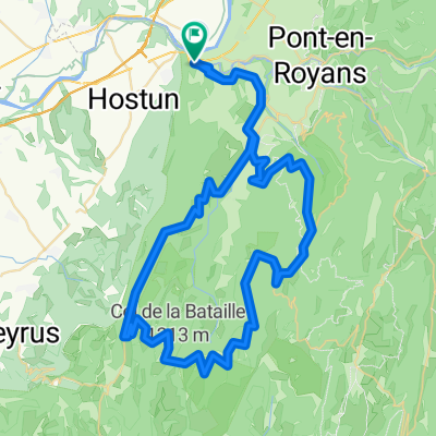
Col de Toutes Aures-Presles-Malleval
A cycling route starting in Saint-Just-de-Claix, Auvergne-Rhône-Alpes, France.
Overview
About this route
Start bei Möbel Gabayet -Parkplatz vor St. Just-de-Claix.
Einfahren nach Pont-en-Royans
Aufstieg nach Presles über Col de Toutes Aures - unvergleichliche Landschaft- Blick über das Tal der Bourne
Weiter über Le Faz und den Pas du Pré Coquet runter nach Malleval und durch die Gorges de Nan nach Cognin.
Zurück über die D 1532 nach St. Just de Claix.
Landschaftlich einmalige Tour
- -:--
- Duration
- 56.8 km
- Distance
- 1,674 m
- Ascent
- 1,650 m
- Descent
- ---
- Avg. speed
- 1,290 m
- Max. altitude
Route quality
Waytypes & surfaces along the route
Waytypes
Road
24.5 km
(43 %)
Busy road
21.2 km
(37 %)
Surfaces
Paved
27.8 km
(49 %)
Unpaved
0.9 km
(2 %)
Asphalt
27.6 km
(49 %)
Ground
0.5 km
(<1 %)
Continue with Bikemap
Use, edit, or download this cycling route
You would like to ride Col de Toutes Aures-Presles-Malleval or customize it for your own trip? Here is what you can do with this Bikemap route:
Free features
- Save this route as favorite or in collections
- Copy & plan your own version of this route
- Sync your route with Garmin or Wahoo
Premium features
Free trial for 3 days, or one-time payment. More about Bikemap Premium.
- Navigate this route on iOS & Android
- Export a GPX / KML file of this route
- Create your custom printout (try it for free)
- Download this route for offline navigation
Discover more Premium features.
Get Bikemap PremiumFrom our community
Other popular routes starting in Saint-Just-de-Claix
 SAINT NAZAIRE - SETE
- Distance
- 397.6 km
- Ascent
- 131 m
- Descent
- 289 m
- Location
- Saint-Just-de-Claix, Auvergne-Rhône-Alpes, France
 Saint-Nazaire-en-Royans - Col de la Machine - Col du Pionier
- Distance
- 46.4 km
- Ascent
- 1,511 m
- Descent
- 1,435 m
- Location
- Saint-Just-de-Claix, Auvergne-Rhône-Alpes, France
 14. Tag Sint Nazare en Royans- Grenoble
- Distance
- 102 km
- Ascent
- 1,185 m
- Descent
- 1,151 m
- Location
- Saint-Just-de-Claix, Auvergne-Rhône-Alpes, France
 Combe Laval - Bataille
- Distance
- 79.4 km
- Ascent
- 2,424 m
- Descent
- 2,373 m
- Location
- Saint-Just-de-Claix, Auvergne-Rhône-Alpes, France
 1 Vercors/Drome St Nazaire
- Distance
- 64.5 km
- Ascent
- 1,445 m
- Descent
- 1,443 m
- Location
- Saint-Just-de-Claix, Auvergne-Rhône-Alpes, France
 Col de Toutes Aures-Presles-Malleval
- Distance
- 56.8 km
- Ascent
- 1,674 m
- Descent
- 1,650 m
- Location
- Saint-Just-de-Claix, Auvergne-Rhône-Alpes, France
 tour de l`avenir stage 5 itt
- Distance
- 29.8 km
- Ascent
- 393 m
- Descent
- 276 m
- Location
- Saint-Just-de-Claix, Auvergne-Rhône-Alpes, France
 Etapa 082B (Saint Nazaire en Royans - Le Bourg d'Oisans)
- Distance
- 151.4 km
- Ascent
- 2,783 m
- Descent
- 2,226 m
- Location
- Saint-Just-de-Claix, Auvergne-Rhône-Alpes, France
Open it in the app