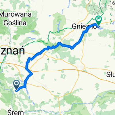
Sobotnie otwarcie
A cycling route starting in K贸rnik, Greater Poland Voivodeship, Poland.
Overview
About this route
Trasa wok贸艂 jeziora bni艅skiego, uzupe艂niona o Rynek w K贸rniku i promenad臋.
- -:--
- Duration
- 17.8 km
- Distance
- 32 m
- Ascent
- 33 m
- Descent
- ---
- Avg. speed
- ---
- Avg. speed
Route quality
Waytypes & surfaces along the route
Waytypes
Road
8.2 km
(46 %)
Quiet road
4.8 km
(27 %)
Surfaces
Paved
8.4 km
(47 %)
Unpaved
0.8 km
(5 %)
Asphalt
6 km
(34 %)
Paving stones
2.4 km
(14 %)
Route highlights
Points of interest along the route
Point of interest after 14.9 km
Continue with Bikemap
Use, edit, or download this cycling route
You would like to ride Sobotnie otwarcie or customize it for your own trip? Here is what you can do with this Bikemap route:
Free features
- Save this route as favorite or in collections
- Copy & plan your own version of this route
- Sync your route with Garmin or Wahoo
Premium features
Free trial for 3 days, or one-time payment. More about Bikemap Premium.
- Navigate this route on iOS & Android
- Export a GPX / KML file of this route
- Create your custom printout (try it for free)
- Download this route for offline navigation
Discover more Premium features.
Get Bikemap PremiumFrom our community
Other popular routes starting in K贸rnik
- G艂贸wna 10, Dzie膰mierowo do Plac Niepodleg艂o艣ci, K贸rnik
- Distance
- 21.7 km
- Ascent
- 82 m
- Descent
- 92 m
- Location
- K贸rnik, Greater Poland Voivodeship, Poland
- Sobotnie otwarcie
- Distance
- 17.8 km
- Ascent
- 32 m
- Descent
- 33 m
- Location
- K贸rnik, Greater Poland Voivodeship, Poland
- K贸rnik-Zaniemy艣l-艢roda-艢r贸dka-K贸rnik
- Distance
- 55.7 km
- Ascent
- 65 m
- Descent
- 65 m
- Location
- K贸rnik, Greater Poland Voivodeship, Poland
- Pogorzelica-przeprawa
- Distance
- 107.7 km
- Ascent
- 154 m
- Descent
- 154 m
- Location
- K贸rnik, Greater Poland Voivodeship, Poland
- K贸rnik - Zaniemy艣l - Czmoniec
- Distance
- 55.2 km
- Ascent
- 97 m
- Descent
- 97 m
- Location
- K贸rnik, Greater Poland Voivodeship, Poland
- K脫RNICKI PIER艢CIE艃 ROWEROWY
- Distance
- 55.1 km
- Ascent
- 97 m
- Descent
- 97 m
- Location
- K贸rnik, Greater Poland Voivodeship, Poland
- Bnin - Herman贸w
- Distance
- 62.1 km
- Ascent
- 101 m
- Descent
- 97 m
- Location
- K贸rnik, Greater Poland Voivodeship, Poland
- Powolna trasa w K贸rnik
- Distance
- 12 km
- Ascent
- 73 m
- Descent
- 72 m
- Location
- K贸rnik, Greater Poland Voivodeship, Poland
Open it in the app