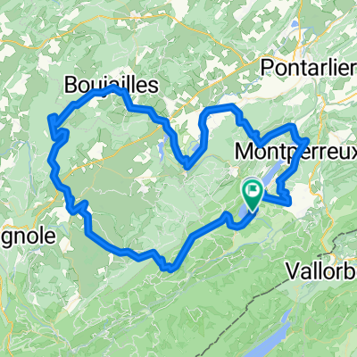
Grande Traversée du Jura - Etape 3 : Métabief / Les Rousses (65 km / D+ 1300 m)
A cycling route starting in Jougne, Bourgogne-Franche-Comté, France.
Overview
About this route
- -:--
- Duration
- 64.9 km
- Distance
- 1,028 m
- Ascent
- 887 m
- Descent
- ---
- Avg. speed
- ---
- Max. altitude
Route highlights
Points of interest along the route
Drinking water after 0.6 km
Télésiège du Morond ouvert à partir du 8 mai
Point of interest after 4.9 km
Le Morond, vue sur les Alpes
Point of interest after 6.9 km
Le Mont d'Or (1463 m), vue sur les Alpes
Point of interest after 21.9 km
Source du Doubs
Point of interest after 22.5 km
Tourbière de Mouthe
Accommodation after 49.2 km
Gîte d'étape Chalet Gaillard - Bois d'Amont (20 p) 03 84 60 94 13
Point of interest after 50.1 km
Lacs des Mortes et de Bellefontaine (tourbières)
Accommodation after 52.6 km
Village de vacances Cévéo, Les chevreuils - Bellefontaine, 103 rue du jeu de quilles (95 p) 03 84 34 64 00
Point of interest after 55.9 km
Forêt du Risoux
Accommodation after 57 km
Gite d'étape Le Montagnard - Bois d'Amont, 1940 rue de Franche-Comté (14 p) 03 84 60 92 62
Accommodation after 63.9 km
Gite d'étape Le Grand Tétras - Les Rousses, 705 route des Rousses d'Amont (50 p) 03 84 60 51 13 ou 06 20 96 15 41
Accommodation after 64.5 km
Hôtel-Restaurant La Redoute - Les Rousses, 357 route Blanche (68 p) 03 84 60 00 40
Accommodation after 64.9 km
Motel La Babaute - Les Rousses, Le Tabagnoz (64 p) 03 84 60 08 00
Accommodation after 64.9 km
Hôtel Arbézie - Les Rousses / La Cure, 601 rue de la Frontière (24 p) 03 84 60 02 20
Accommodation after 64.9 km
Hôtel La Darbella - Prémanon, 551 route de La Darbella (55 p) 03 84 60 78 30
Accommodation after 64.9 km
Chalet des Tuffes - Les Rousses / La Cure, Route de la Faucille (42 p) 03 84 60 02 95
Accommodation after 64.9 km
Gite d'étape La Grenotte - Premanon, Chemin du Bief de la Chaille (38 p) 03 84 60 54 82
Continue with Bikemap
Use, edit, or download this cycling route
You would like to ride Grande Traversée du Jura - Etape 3 : Métabief / Les Rousses (65 km / D+ 1300 m) or customize it for your own trip? Here is what you can do with this Bikemap route:
Free features
- Save this route as favorite or in collections
- Copy & plan your own version of this route
- Sync your route with Garmin or Wahoo
Premium features
Free trial for 3 days, or one-time payment. More about Bikemap Premium.
- Navigate this route on iOS & Android
- Export a GPX / KML file of this route
- Create your custom printout (try it for free)
- Download this route for offline navigation
Discover more Premium features.
Get Bikemap PremiumFrom our community
Other popular routes starting in Jougne
Grande Traversée du Jura - Etape 3 : Métabief / Les Rousses (65 km / D+ 1300 m)- Distance
- 64.9 km
- Ascent
- 1,028 m
- Descent
- 887 m
- Location
- Jougne, Bourgogne-Franche-Comté, France
Jura Tour: Malbuisson -> Les Molunes- Distance
- 92.2 km
- Ascent
- 1,403 m
- Descent
- 1,078 m
- Location
- Jougne, Bourgogne-Franche-Comté, France
Hôpitaux Neufs Mots du Jura F/CH- Distance
- 85.3 km
- Ascent
- 1,636 m
- Descent
- 1,634 m
- Location
- Jougne, Bourgogne-Franche-Comté, France
lac st-point tour- Distance
- 20.1 km
- Ascent
- 177 m
- Descent
- 163 m
- Location
- Jougne, Bourgogne-Franche-Comté, France
Domingo de Manhattan- Distance
- 62.1 km
- Ascent
- 258 m
- Descent
- 833 m
- Location
- Jougne, Bourgogne-Franche-Comté, France
Lac de Remoray-Mouthe- Distance
- 48.4 km
- Ascent
- 723 m
- Descent
- 649 m
- Location
- Jougne, Bourgogne-Franche-Comté, France
around Saint-point lake- Distance
- 23.7 km
- Ascent
- 139 m
- Descent
- 122 m
- Location
- Jougne, Bourgogne-Franche-Comté, France
Jura Val de Mouthe- Distance
- 30 km
- Ascent
- 429 m
- Descent
- 430 m
- Location
- Jougne, Bourgogne-Franche-Comté, France
Open it in the app

