

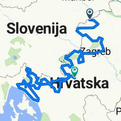
žetale-sladka gora-poljčane-ptujska gora-žetale
A cycling route starting in Žetale, Občina Žetale, Slovenia.
Overview
About this route
- -:--
- Duration
- 72.8 km
- Distance
- 548 m
- Ascent
- 548 m
- Descent
- ---
- Avg. speed
- ---
- Max. altitude

Route quality
Waytypes & surfaces along the route
Waytypes
Road
22.6 km
(31 %)
Quiet road
2.2 km
(3 %)
Undefined
48.1 km
(66 %)
Surfaces
Paved
47.3 km
(65 %)
Asphalt
47.3 km
(65 %)
Undefined
25.5 km
(35 %)
Continue with Bikemap
Use, edit, or download this cycling route
You would like to ride žetale-sladka gora-poljčane-ptujska gora-žetale or customize it for your own trip? Here is what you can do with this Bikemap route:
Free features
- Save this route as favorite or in collections
- Copy & plan your own version of this route
- Sync your route with Garmin or Wahoo
Premium features
Free trial for 3 days, or one-time payment. More about Bikemap Premium.
- Navigate this route on iOS & Android
- Export a GPX / KML file of this route
- Create your custom printout (try it for free)
- Download this route for offline navigation
Discover more Premium features.
Get Bikemap PremiumFrom our community
Other popular routes starting in Žetale
 težja, slo kolesari thour de žetale
- Distance
- 50.6 km
- Ascent
- 910 m
- Descent
- 926 m
- Location
- Žetale, Občina Žetale, Slovenia
 Slovenija kolesari lažja pot
- Distance
- 41.2 km
- Ascent
- 565 m
- Descent
- 565 m
- Location
- Žetale, Občina Žetale, Slovenia
 žetale-sladka gora-poljčane-ptujska gora-žetale
- Distance
- 72.8 km
- Ascent
- 548 m
- Descent
- 548 m
- Location
- Žetale, Občina Žetale, Slovenia
 Haloze
- Distance
- 62 km
- Ascent
- 496 m
- Descent
- 493 m
- Location
- Žetale, Občina Žetale, Slovenia
 6.den
6.den- Distance
- 145.2 km
- Ascent
- 907 m
- Descent
- 1,171 m
- Location
- Žetale, Občina Žetale, Slovenia
 easyroad 01
- Distance
- 785.2 km
- Ascent
- 4,071 m
- Descent
- 4,243 m
- Location
- Žetale, Občina Žetale, Slovenia
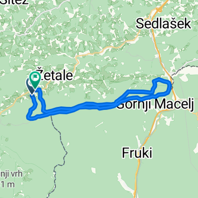 Obnčina_Žetale_Čermožiše_Macelj
- Distance
- 17 km
- Ascent
- 950 m
- Descent
- 959 m
- Location
- Žetale, Občina Žetale, Slovenia
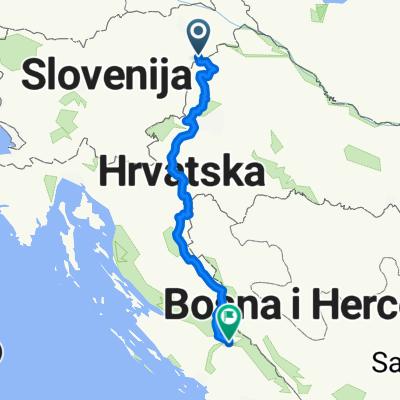 macelj - knin
- Distance
- 402.7 km
- Ascent
- 2,186 m
- Descent
- 2,200 m
- Location
- Žetale, Občina Žetale, Slovenia
Open it in the app