

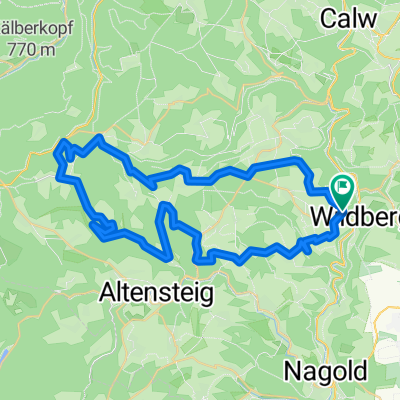
Wildberg - Nagold - Mötzingen - Jettingen
A cycling route starting in Wildberg, Baden-Wurttemberg, Germany.
Overview
About this route
Schöne Strecke mit knapp 600 Höhenmeter. 80 % Asphalt. Der Rest Schotter bzw. Fewldweg
- -:--
- Duration
- 37.5 km
- Distance
- 374 m
- Ascent
- 374 m
- Descent
- ---
- Avg. speed
- ---
- Max. altitude

Route quality
Waytypes & surfaces along the route
Waytypes
Track
23.2 km
(62 %)
Quiet road
6.6 km
(18 %)
Surfaces
Paved
32.3 km
(86 %)
Unpaved
2.8 km
(7 %)
Asphalt
30.7 km
(82 %)
Gravel
1.9 km
(5 %)
Continue with Bikemap
Use, edit, or download this cycling route
You would like to ride Wildberg - Nagold - Mötzingen - Jettingen or customize it for your own trip? Here is what you can do with this Bikemap route:
Free features
- Save this route as favorite or in collections
- Copy & plan your own version of this route
- Sync your route with Garmin or Wahoo
Premium features
Free trial for 3 days, or one-time payment. More about Bikemap Premium.
- Navigate this route on iOS & Android
- Export a GPX / KML file of this route
- Create your custom printout (try it for free)
- Download this route for offline navigation
Discover more Premium features.
Get Bikemap PremiumFrom our community
Other popular routes starting in Wildberg
 Tour Schwarzwald - Wildberg
- Distance
- 51.7 km
- Ascent
- 796 m
- Descent
- 770 m
- Location
- Wildberg, Baden-Wurttemberg, Germany
 Wildberg - Nagold - Mötzingen - Jettingen
- Distance
- 37.5 km
- Ascent
- 374 m
- Descent
- 374 m
- Location
- Wildberg, Baden-Wurttemberg, Germany
 Effringen nach Kirchheim
- Distance
- 72.5 km
- Ascent
- 656 m
- Descent
- 863 m
- Location
- Wildberg, Baden-Wurttemberg, Germany
 Über 6 Anstiege im Nordschwarzwald
- Distance
- 132.1 km
- Ascent
- 2,100 m
- Descent
- 2,100 m
- Location
- Wildberg, Baden-Wurttemberg, Germany
 22-xx_Su_Si_He_Gä_34km_450Hm
- Distance
- 33.7 km
- Ascent
- 518 m
- Descent
- 511 m
- Location
- Wildberg, Baden-Wurttemberg, Germany
 Rothfelden / Nagold
- Distance
- 25.3 km
- Ascent
- 324 m
- Descent
- 328 m
- Location
- Wildberg, Baden-Wurttemberg, Germany
 Blick in den Schwarzwald
- Distance
- 30.5 km
- Ascent
- 480 m
- Descent
- 476 m
- Location
- Wildberg, Baden-Wurttemberg, Germany
 Oberkollwangen-Hofstett-Hornberg-Gaugenwald
- Distance
- 47.1 km
- Ascent
- 684 m
- Descent
- 686 m
- Location
- Wildberg, Baden-Wurttemberg, Germany
Open it in the app