

Mittlere Sonntagstour
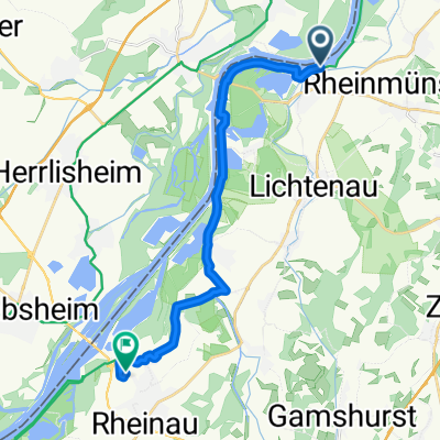
A cycling route starting in Rheinmünster, Baden-Wurttemberg, Germany.
Overview
About this route
Wie auch die kleine Sonntagstour führt diese Tour an einer Eisdiele am Johannesplatz in Bühl vorbei. Geeignet für Kinder allerdings eher für Mountainbikes oder Trekkingfahrrad da auch Waldwege und teilweise unbefestigte Wege gefahren wurden. Teilweise fahren auf der Hauptstrasse.
- -:--
- Duration
- 32.3 km
- Distance
- 36 m
- Ascent
- 36 m
- Descent
- ---
- Avg. speed
- ---
- Max. altitude
Route quality
Waytypes & surfaces along the route
Waytypes
Track
14.7 km
(46 %)
Quiet road
7 km
(22 %)
Surfaces
Paved
20.3 km
(63 %)
Unpaved
9 km
(28 %)
Asphalt
14.8 km
(46 %)
Paved (undefined)
4.3 km
(13 %)
Continue with Bikemap
Use, edit, or download this cycling route
You would like to ride Mittlere Sonntagstour or customize it for your own trip? Here is what you can do with this Bikemap route:
Free features
- Save this route as favorite or in collections
- Copy & plan your own version of this route
- Sync your route with Garmin or Wahoo
Premium features
Free trial for 3 days, or one-time payment. More about Bikemap Premium.
- Navigate this route on iOS & Android
- Export a GPX / KML file of this route
- Create your custom printout (try it for free)
- Download this route for offline navigation
Discover more Premium features.
Get Bikemap PremiumFrom our community
Other popular routes starting in Rheinmünster
 Hinter den Gärten 1, Rheinmünster nach Gartenstraße 2A, Au am Rhein
- Distance
- 33.7 km
- Ascent
- 231 m
- Descent
- 246 m
- Location
- Rheinmünster, Baden-Wurttemberg, Germany
 Industriestraße 11–15, Rheinmünster nach Hauptstraße 15, Sinzheim
- Distance
- 14.6 km
- Ascent
- 9 m
- Descent
- 6 m
- Location
- Rheinmünster, Baden-Wurttemberg, Germany
 Schifferweg 4, Rheinmünster nach K3744, Lichtenau
- Distance
- 4.6 km
- Ascent
- 38 m
- Descent
- 15 m
- Location
- Rheinmünster, Baden-Wurttemberg, Germany
 Schifferweg to Im Bahnwörtel
- Distance
- 16.1 km
- Ascent
- 17 m
- Descent
- 60 m
- Location
- Rheinmünster, Baden-Wurttemberg, Germany
 Greffern - Mülligen
- Distance
- 281.3 km
- Ascent
- 335 m
- Descent
- 101 m
- Location
- Rheinmünster, Baden-Wurttemberg, Germany
 Recovered Route
- Distance
- 6.4 km
- Ascent
- 6 m
- Descent
- 4 m
- Location
- Rheinmünster, Baden-Wurttemberg, Germany
 L75, Rheinmünster nach 6 Rue Cerf Berr, Straßburg
- Distance
- 45.4 km
- Ascent
- 245 m
- Descent
- 223 m
- Location
- Rheinmünster, Baden-Wurttemberg, Germany
 Zur Rheinfähre, Rheinmünster nach Geppertstraße 21, Bühl
- Distance
- 14.4 km
- Ascent
- 23 m
- Descent
- 14 m
- Location
- Rheinmünster, Baden-Wurttemberg, Germany
Open it in the app