

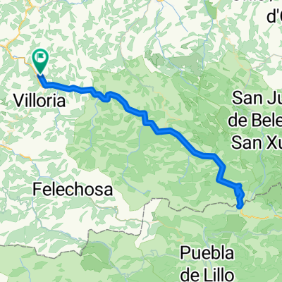
LAVIANA - CABAÑAQUINTA - SAN ISIDRO - LAS SEÑALES - TARNA - LAVIANA
A cycling route starting in Pola de Laviana, Principality of Asturias, Spain.
Overview
About this route
CIRCULAR ROUTE START AND FINISH IN POLA LAVIANA, PERFECT FOR RIDING IN EITHER DIRECTION.
OPTION 1 Starting from Laviana heading towards Alto La Colladona (AS-252) to reach Cabañaquinta and begin the ascent to San Isidro (AS-253).
Once topped out, continue through the neighboring community to Puebla de Lillo where we will turn left to continue on the (LE-333) to tackle the Puerto de las Señales and reach the Puerto del Tarna on the León side, then descend via AS-17 along the reservoirs back to Laviana.
OPTION 2 Start from Laviana towards Tarna on AS-17, once you have crested the pass with barely any rest, turn right to face the Puerto de las Señales on its northern slope (LE-333).
After reaching 1625m, descend and before arriving at Puebla de Lillo turn right (LE-332) to tackle San Isidro on its southern slope and then descend to Cabañaquinta where we will turn right again to take AS-252 and begin the climb to the Alto de la Collada which will take us back to Laviana.
- -:--
- Duration
- 119.7 km
- Distance
- 2,142 m
- Ascent
- 2,142 m
- Descent
- ---
- Avg. speed
- ---
- Max. altitude

Route quality
Waytypes & surfaces along the route
Waytypes
Road
19.2 km
(16 %)
Quiet road
2.4 km
(2 %)
Surfaces
Paved
97 km
(81 %)
Asphalt
97 km
(81 %)
Undefined
22.7 km
(19 %)
Continue with Bikemap
Use, edit, or download this cycling route
You would like to ride LAVIANA - CABAÑAQUINTA - SAN ISIDRO - LAS SEÑALES - TARNA - LAVIANA or customize it for your own trip? Here is what you can do with this Bikemap route:
Free features
- Save this route as favorite or in collections
- Copy & plan your own version of this route
- Split it into stages to create a multi-day tour
- Sync your route with Garmin or Wahoo
Premium features
Free trial for 3 days, or one-time payment. More about Bikemap Premium.
- Navigate this route on iOS & Android
- Export a GPX / KML file of this route
- Create your custom printout (try it for free)
- Download this route for offline navigation
Discover more Premium features.
Get Bikemap PremiumFrom our community
Other popular routes starting in Pola de Laviana
 Asturias-07: Pola de Laviana - la Uña
- Distance
- 60.1 km
- Ascent
- 1,887 m
- Descent
- 1,039 m
- Location
- Pola de Laviana, Principality of Asturias, Spain
 LAVIANA - CABAÑAQUINTA - SAN ISIDRO - LAS SEÑALES - TARNA - LAVIANA
- Distance
- 119.7 km
- Ascent
- 2,142 m
- Descent
- 2,142 m
- Location
- Pola de Laviana, Principality of Asturias, Spain
 Laviana - Puerto de Tarna - Laviana
- Distance
- 94.4 km
- Ascent
- 1,322 m
- Descent
- 1,322 m
- Location
- Pola de Laviana, Principality of Asturias, Spain
 Puerto Tarna/Señales - Puerto San Isidro - La Colladona
- Distance
- 119 km
- Ascent
- 2,208 m
- Descent
- 2,208 m
- Location
- Pola de Laviana, Principality of Asturias, Spain
 Laviana-San Mamés-Laviana
- Distance
- 16.8 km
- Ascent
- 347 m
- Descent
- 348 m
- Location
- Pola de Laviana, Principality of Asturias, Spain
 Asturias-06: Pola Laviana - Puebla de Lillo
- Distance
- 55.3 km
- Ascent
- 7,288 m
- Descent
- 7,617 m
- Location
- Pola de Laviana, Principality of Asturias, Spain
 ETAPA 1 2025
- Distance
- 95.7 km
- Ascent
- 1,825 m
- Descent
- 1,948 m
- Location
- Pola de Laviana, Principality of Asturias, Spain
 Pola de Laviana-formenbeja-soto de llorio-pola de laviana
- Distance
- 20.7 km
- Ascent
- 509 m
- Descent
- 506 m
- Location
- Pola de Laviana, Principality of Asturias, Spain
Open it in the app