

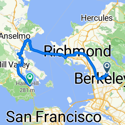
Grizzly to Lake Merrit
A cycling route starting in Berkeley, California, United States.
Overview
About this route
From Grizzly Peak Blvd near Marin in Berkeley to Children's Fairyland near Lake Merrit in Oakland.
1000ft drop or gain ...
- -:--
- Duration
- 12.4 km
- Distance
- 13 m
- Ascent
- 329 m
- Descent
- ---
- Avg. speed
- ---
- Max. altitude
Route quality
Waytypes & surfaces along the route
Waytypes
Quiet road
9.1 km
(74 %)
Road
2.7 km
(22 %)
Surfaces
Paved
12 km
(97 %)
Asphalt
11.4 km
(92 %)
Concrete
0.5 km
(4 %)
Continue with Bikemap
Use, edit, or download this cycling route
You would like to ride Grizzly to Lake Merrit or customize it for your own trip? Here is what you can do with this Bikemap route:
Free features
- Save this route as favorite or in collections
- Copy & plan your own version of this route
- Sync your route with Garmin or Wahoo
Premium features
Free trial for 3 days, or one-time payment. More about Bikemap Premium.
- Navigate this route on iOS & Android
- Export a GPX / KML file of this route
- Create your custom printout (try it for free)
- Download this route for offline navigation
Discover more Premium features.
Get Bikemap PremiumFrom our community
Other popular routes starting in Berkeley
 Spruce Wildcat Orinda Toyonal (SWOT)
- Distance
- 30.1 km
- Ascent
- 759 m
- Descent
- 759 m
- Location
- Berkeley, California, United States
 Three Bears
- Distance
- 58.3 km
- Ascent
- 1,476 m
- Descent
- 1,476 m
- Location
- Berkeley, California, United States
 johanna smooth ride
- Distance
- 49.4 km
- Ascent
- 419 m
- Descent
- 632 m
- Location
- Berkeley, California, United States
 Berkeley Ride
- Distance
- 48.4 km
- Ascent
- 838 m
- Descent
- 853 m
- Location
- Berkeley, California, United States
 Wildcat Canyon o&b + Briones Park circuit
- Distance
- 60.3 km
- Ascent
- 1,429 m
- Descent
- 1,458 m
- Location
- Berkeley, California, United States
 NB BART To Inspiration Point
- Distance
- 22.7 km
- Ascent
- 425 m
- Descent
- 424 m
- Location
- Berkeley, California, United States
 small loop
- Distance
- 15 km
- Ascent
- 379 m
- Descent
- 379 m
- Location
- Berkeley, California, United States
 Innersport to 3 Bears (clockwise) and return
- Distance
- 78 km
- Ascent
- 1,010 m
- Descent
- 1,010 m
- Location
- Berkeley, California, United States
Open it in the app