UNSER LAND St. Veit - Villach
A cycling route starting in Sankt Veit an der Glan, Carinthia, Austria.
Overview
About this route
Unser Land erfahren 2020
Strecke St. Veit / Glan - Feldkirchen - Villach
- -:--
- Duration
- 54.9 km
- Distance
- 207 m
- Ascent
- 189 m
- Descent
- ---
- Avg. speed
- ---
- Avg. speed
Route quality
Waytypes & surfaces along the route
Waytypes
Busy road
15.8 km
(29 %)
Cycleway
13.5 km
(25 %)
Surfaces
Paved
35.7 km
(65 %)
Unpaved
6.4 km
(12 %)
Asphalt
32.7 km
(60 %)
Gravel
5.6 km
(10 %)
Route highlights
Points of interest along the route
Point of interest after 27.5 km
Bahnhof Feldkirchen in Kärnten
Point of interest after 39.1 km
Labestation Ossiach
Continue with Bikemap
Use, edit, or download this cycling route
You would like to ride UNSER LAND St. Veit - Villach or customize it for your own trip? Here is what you can do with this Bikemap route:
Free features
- Save this route as favorite or in collections
- Copy & plan your own version of this route
- Sync your route with Garmin or Wahoo
Premium features
Free trial for 3 days, or one-time payment. More about Bikemap Premium.
- Navigate this route on iOS & Android
- Export a GPX / KML file of this route
- Create your custom printout (try it for free)
- Download this route for offline navigation
Discover more Premium features.
Get Bikemap PremiumFrom our community
Other popular routes starting in Sankt Veit an der Glan
- St. Veiter Runde
- Distance
- 55.4 km
- Ascent
- 626 m
- Descent
- 626 m
- Location
- Sankt Veit an der Glan, Carinthia, Austria
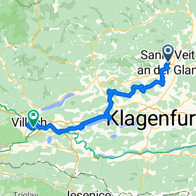
- St. Veit an der Glan - Brückl - Völkermarkt - Maria Saal - St. Veit an der Glan CLONED FROM ROUTE 275135
- Distance
- 71.4 km
- Ascent
- 507 m
- Descent
- 505 m
- Location
- Sankt Veit an der Glan, Carinthia, Austria
- Kleine Scheifling/Taggenbrunnrunde
- Distance
- 9 km
- Ascent
- 218 m
- Descent
- 220 m
- Location
- Sankt Veit an der Glan, Carinthia, Austria
- SV-Kalkgruber-Panotsch-Zwein-SV
- Distance
- 22.3 km
- Ascent
- 672 m
- Descent
- 672 m
- Location
- Sankt Veit an der Glan, Carinthia, Austria
- RR-Berg: St.Veit-KleinSt.Veit-Haimburg-Diex-Brückl-Diex-Brückl-St.Veit
- Distance
- 74.9 km
- Ascent
- 913 m
- Descent
- 913 m
- Location
- Sankt Veit an der Glan, Carinthia, Austria
- RR-Flach: St.Veit-Brückl-Haimburg-Völkermarkt-St.MichaelGurk-Pischeldorf-St.MichaelZollfeld-St.Veit
- Distance
- 75.6 km
- Ascent
- 439 m
- Descent
- 438 m
- Location
- Sankt Veit an der Glan, Carinthia, Austria
- St Veit - Wimitz - Sirnitz - Straßburg - St. Veit
- Distance
- 97.5 km
- Ascent
- 2,251 m
- Descent
- 2,253 m
- Location
- Sankt Veit an der Glan, Carinthia, Austria
- UNSER LAND St. Veit - Villach
- Distance
- 54.9 km
- Ascent
- 207 m
- Descent
- 189 m
- Location
- Sankt Veit an der Glan, Carinthia, Austria
Open it in the app