

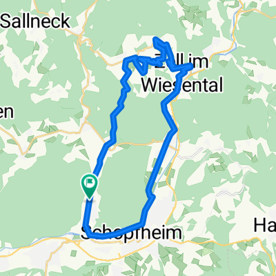
Schopfheim Sutz-Latringen
A cycling route starting in Schopfheim, Baden-Wurttemberg, Germany.
Overview
About this route
- -:--
- Duration
- 123 km
- Distance
- 804 m
- Ascent
- 731 m
- Descent
- ---
- Avg. speed
- 736 m
- Max. altitude

Route quality
Waytypes & surfaces along the route
Waytypes
Quiet road
23.4 km
(19 %)
Path
8.6 km
(7 %)
Surfaces
Paved
88.5 km
(72 %)
Unpaved
3.7 km
(3 %)
Asphalt
86.1 km
(70 %)
Paved (undefined)
2.5 km
(2 %)
Continue with Bikemap
Use, edit, or download this cycling route
You would like to ride Schopfheim Sutz-Latringen or customize it for your own trip? Here is what you can do with this Bikemap route:
Free features
- Save this route as favorite or in collections
- Copy & plan your own version of this route
- Split it into stages to create a multi-day tour
- Sync your route with Garmin or Wahoo
Premium features
Free trial for 3 days, or one-time payment. More about Bikemap Premium.
- Navigate this route on iOS & Android
- Export a GPX / KML file of this route
- Create your custom printout (try it for free)
- Download this route for offline navigation
Discover more Premium features.
Get Bikemap PremiumFrom our community
Other popular routes starting in Schopfheim
 Friedrichstraße 9, Schopfheim nach Friedrichstraße 7, Schopfheim
- Distance
- 15.4 km
- Ascent
- 162 m
- Descent
- 152 m
- Location
- Schopfheim, Baden-Wurttemberg, Germany
 Schopfheim Sutz-Latringen
- Distance
- 123 km
- Ascent
- 804 m
- Descent
- 731 m
- Location
- Schopfheim, Baden-Wurttemberg, Germany
 schopfheim Schaui Freiburg
- Distance
- 56.2 km
- Ascent
- 1,400 m
- Descent
- 1,062 m
- Location
- Schopfheim, Baden-Wurttemberg, Germany
 SchopfheimerHöhenMeterRundfahrt
- Distance
- 82.8 km
- Ascent
- 1,704 m
- Descent
- 1,458 m
- Location
- Schopfheim, Baden-Wurttemberg, Germany
 Schopfheim - Schlächtenhaus - Hauingen - Schopfheim
- Distance
- 36.9 km
- Ascent
- 490 m
- Descent
- 488 m
- Location
- Schopfheim, Baden-Wurttemberg, Germany
 Blünimattstraße 9A, Schopfheim nach Blünimattstraße 9A, Schopfheim
- Distance
- 24.9 km
- Ascent
- 554 m
- Descent
- 556 m
- Location
- Schopfheim, Baden-Wurttemberg, Germany
 Schopfheim-Neuenweg-Zell-Schopfheim
- Distance
- 49.3 km
- Ascent
- 1,091 m
- Descent
- 1,025 m
- Location
- Schopfheim, Baden-Wurttemberg, Germany
 20200726 Schopfheim
- Distance
- 68.6 km
- Ascent
- 401 m
- Descent
- 401 m
- Location
- Schopfheim, Baden-Wurttemberg, Germany
Open it in the app