

Hackelberg Trail
A cycling route starting in Saalbach, Salzburg, Austria.
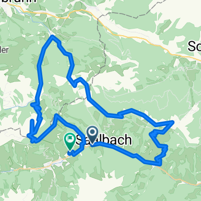
Overview
About this route
Der Hackelberg Trail ist der Klassiker unter den Bike Trails in Saalbach Hinterglemm. Er startet bei der Westgipfelhütte und endet an der Hackelberg Alm oberhalb von Hinterglemm. Die Alm lockt mit einer tollen Sonnenterrasse zum verweilen und zur Einkehr. Weiter geht es entweder auf Forstweg nach Hinterglemm, oder über den Bergstadel und den Buchegg Trail ebenfalls ins Tal.
- -:--
- Duration
- 2.5 km
- Distance
- 18 m
- Ascent
- 343 m
- Descent
- ---
- Avg. speed
- ---
- Avg. speed

Continue with Bikemap
Use, edit, or download this cycling route
You would like to ride Hackelberg Trail or customize it for your own trip? Here is what you can do with this Bikemap route:
Free features
- Save this route as favorite or in collections
- Copy & plan your own version of this route
- Sync your route with Garmin or Wahoo
Premium features
Free trial for 3 days, or one-time payment. More about Bikemap Premium.
- Navigate this route on iOS & Android
- Export a GPX / KML file of this route
- Create your custom printout (try it for free)
- Download this route for offline navigation
Discover more Premium features.
Get Bikemap PremiumFrom our community
Other popular routes starting in Saalbach
 Schattberg-Ostgipfel-Westgipfel-Runde
- Distance
- 28.1 km
- Ascent
- 1,178 m
- Descent
- 1,181 m
- Location
- Saalbach, Salzburg, Austria
 Saalbach-Asitz-Leogang-Hochfilzen-Saalbach
- Distance
- 48.9 km
- Ascent
- 1,950 m
- Descent
- 1,945 m
- Location
- Saalbach, Salzburg, Austria
 Saalbach-Hinterglemm part 2
- Distance
- 19.9 km
- Ascent
- 640 m
- Descent
- 918 m
- Location
- Saalbach, Salzburg, Austria
 SH 40 Hochalm - Trail - Runde
- Distance
- 23.4 km
- Ascent
- 951 m
- Descent
- 950 m
- Location
- Saalbach, Salzburg, Austria
 Gravel Austria, Etappe Salzburg
- Distance
- 257.6 km
- Ascent
- 5,510 m
- Descent
- 6,342 m
- Location
- Saalbach, Salzburg, Austria
 Saalbach - Spielbergalm - Schattberg - Saalbach
- Distance
- 37.9 km
- Ascent
- 1,768 m
- Descent
- 1,768 m
- Location
- Saalbach, Salzburg, Austria
 Saalbach 2009 - Jausern, Schonleitenhutte, SpielbergHaus, BurgerAlm, ReiterKogel
- Distance
- 46.2 km
- Ascent
- 1,975 m
- Descent
- 1,903 m
- Location
- Saalbach, Salzburg, Austria
 Panoramaalm Saalbach Med 23
- Distance
- 19.1 km
- Ascent
- 657 m
- Descent
- 656 m
- Location
- Saalbach, Salzburg, Austria
Open it in the app