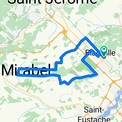
Mirabel-Cylopétards trajet long 45 km
A cycling route starting in Blainville, Quebec, Canada.
Overview
About this route
Departure from the parking lot at Belisle station (Bell Helicopter side)
Head toward the adjacent street and go to join Rue St-Jacques, turn right on St-Jacques.
Turn left on Rang St-Henriette.
Turn right on Rue St-Jean.
Turn left on Rue St-Jacques.
Turn left on Rue St-Jean.
Turn left on Montée Clément.
Turn right on Côte des Saints.
Turn right on Rue St-Vincent then left on Rang St-Rémi.
Turn left on Chemin St-Simon.
Turn left on Blvd Arthur-Sauvé.
Turn left on Rue de Belle-Rivière.
Turn right on Côte des Anges.
Turn left on Montée Dolbie.
Turn left on Côte des Saints.
Turn right on Montée Clément.
Turn right on Rue St-Jean.
Turn left on Mtée Marianne.
Turn right on Rue St-Jacques.
Take the first street on the left to return to the parking lot.
- -:--
- Duration
- 45.9 km
- Distance
- 88 m
- Ascent
- 88 m
- Descent
- ---
- Avg. speed
- ---
- Max. altitude
Route quality
Waytypes & surfaces along the route
Waytypes
Road
38.1 km
(83 %)
Quiet road
5.5 km
(12 %)
Surfaces
Paved
45 km
(98 %)
Asphalt
42.7 km
(93 %)
Paved (undefined)
2.3 km
(5 %)
Undefined
0.9 km
(2 %)
Continue with Bikemap
Use, edit, or download this cycling route
You would like to ride Mirabel-Cylopétards trajet long 45 km or customize it for your own trip? Here is what you can do with this Bikemap route:
Free features
- Save this route as favorite or in collections
- Copy & plan your own version of this route
- Sync your route with Garmin or Wahoo
Premium features
Free trial for 3 days, or one-time payment. More about Bikemap Premium.
- Navigate this route on iOS & Android
- Export a GPX / KML file of this route
- Create your custom printout (try it for free)
- Download this route for offline navigation
Discover more Premium features.
Get Bikemap PremiumFrom our community
Other popular routes starting in Blainville
- CC 2719 route 1
- Distance
- 127 km
- Ascent
- 773 m
- Descent
- 496 m
- Location
- Blainville, Quebec, Canada
- Mirabel-Cylopétards trajet long 45 km
- Distance
- 45.9 km
- Ascent
- 88 m
- Descent
- 88 m
- Location
- Blainville, Quebec, Canada
- ftnb-lorraine
- Distance
- 33 km
- Ascent
- 23 m
- Descent
- 36 m
- Location
- Blainville, Quebec, Canada
- Entraînement
- Distance
- 54.6 km
- Ascent
- 69 m
- Descent
- 65 m
- Location
- Blainville, Quebec, Canada
- De Rue Simon Lussier, Blainville à Rue Charles 18645, Mirabel
- Distance
- 29.4 km
- Ascent
- 221 m
- Descent
- 224 m
- Location
- Blainville, Quebec, Canada
- Domaine Vert - St-Victor - Route Verte
- Distance
- 34.3 km
- Ascent
- 59 m
- Descent
- 59 m
- Location
- Blainville, Quebec, Canada
- De Avenue 48 Est 111, Blainville à Rue Simon Lussier 102, Blainville
- Distance
- 53.3 km
- Ascent
- 485 m
- Descent
- 479 m
- Location
- Blainville, Quebec, Canada
- Ste-Sophie
- Distance
- 49.8 km
- Ascent
- 178 m
- Descent
- 176 m
- Location
- Blainville, Quebec, Canada
Open it in the app