Buchener Herrentorte (Reichelsheim-Buchen)
A cycling route starting in Reichelsheim, Hesse, Germany.
Overview
About this route
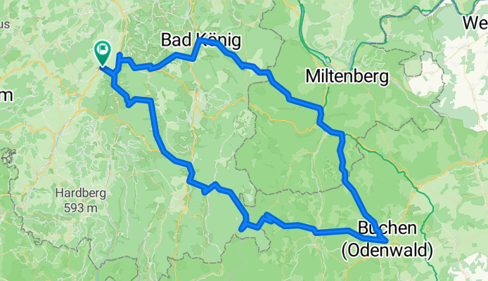
Start and finish is Reichelsheim in the Odenwald
From Reichelsheim, take the B38 to Beefurth, turn right toward Michelstadt (Hutzwiese, Spreng). In Spreng, turn left onto Langenbrombach to Zell, then left to Bad-König, in B.-König right to Kimbach, Vielbrunn, through the Ohrenbachtal to Weilbach, there turn right to Amorbach, Schneeberg, turn right to Zitterfelden. Along the initially well-developed road, at the border only as a bike/pedestrian path, then again well-developed (hence little traffic) to Buchen. Be sure to try the Buchener Herrentorte! Return via Unterneudorf, Rumpfen, Mudau, Schloßau and the Kräsehberg to Hetzbach. In Hetzbach, turn left over the Hetzbach train station and Himbächel viaduct to the B45. After about 1 km, turn left onto Siegfriedstraße to Hüttental, through the Mossautal to Ober-Mossau, there turn left over Rohrbach, Unter-Ostern back to Reichelsheim.
- -:--
- Duration
- 119.2 km
- Distance
- 1,850 m
- Ascent
- 1,721 m
- Descent
- ---
- Avg. speed
- 533 m
- Max. altitude
Route quality
Waytypes & surfaces along the route
Waytypes
Road
27.4 km
(23 %)
Track
13.1 km
(11 %)
Surfaces
Paved
94.2 km
(79 %)
Unpaved
9.5 km
(8 %)
Asphalt
94.2 km
(79 %)
Gravel
7.2 km
(6 %)
Continue with Bikemap
Use, edit, or download this cycling route
You would like to ride Buchener Herrentorte (Reichelsheim-Buchen) or customize it for your own trip? Here is what you can do with this Bikemap route:
Free features
- Save this route as favorite or in collections
- Copy & plan your own version of this route
- Split it into stages to create a multi-day tour
- Sync your route with Garmin or Wahoo
Premium features
Free trial for 3 days, or one-time payment. More about Bikemap Premium.
- Navigate this route on iOS & Android
- Export a GPX / KML file of this route
- Create your custom printout (try it for free)
- Download this route for offline navigation
Discover more Premium features.
Get Bikemap PremiumFrom our community
Other popular routes starting in Reichelsheim
- MTB Odenwald
- Distance
- 34 km
- Ascent
- 637 m
- Descent
- 631 m
- Location
- Reichelsheim, Hesse, Germany
- Laudenau - Eberstadt - Weinheim - Laudenau
- Distance
- 92.3 km
- Ascent
- 617 m
- Descent
- 621 m
- Location
- Reichelsheim, Hesse, Germany
- Reichelsheimer Trainingslager 2011, 3. Tag
- Distance
- 112.4 km
- Ascent
- 1,116 m
- Descent
- 1,116 m
- Location
- Reichelsheim, Hesse, Germany
- Reichelsheim-Watterbach
- Distance
- 94 km
- Ascent
- 1,284 m
- Descent
- 1,293 m
- Location
- Reichelsheim, Hesse, Germany
- Buchener Herrentorte (Reichelsheim-Buchen)
- Distance
- 119.2 km
- Ascent
- 1,850 m
- Descent
- 1,721 m
- Location
- Reichelsheim, Hesse, Germany
- Kaffeefahrt zum Neckar (Reichelsheim-Hirschhorn)
- Distance
- 76.6 km
- Ascent
- 1,462 m
- Descent
- 1,407 m
- Location
- Reichelsheim, Hesse, Germany
- Laudenau - Krehberg -Laudenau
- Distance
- 38.5 km
- Ascent
- 911 m
- Descent
- 913 m
- Location
- Reichelsheim, Hesse, Germany
- RodensteinTour
- Distance
- 11 km
- Ascent
- 268 m
- Descent
- 274 m
- Location
- Reichelsheim, Hesse, Germany
Open it in the app