Lokalne nabijanie kilosów
- 34.7 km
- 87 m
- 87 m
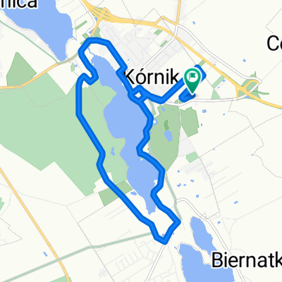
- Kórnik, Greater Poland Voivodeship, Poland
A cycling route starting in Kórnik, Greater Poland Voivodeship, Poland.
Overview
The route is partly on dirt roads, mostly, however, on asphalt local roads (only a small section is traveled along route no. 432). From Bnin to Jeziora Wielkie on asphalt, then we turn onto an unpaved road. The route is not very difficult, you can ride it at about 20 km/h even, so it's okay. I wanted to go to Lucin, because as the cycling trail on the map of the municipality of Śrem shows, but... there is no signage at all in the area! There are two other trails (red and yellow), however, these lead to Zaniemyśl, so it's completely out of the way.
So from Zaniemyśl to Śrem on asphalt. Good route, mainly through forests, so that's fine. I advise against the shortcut (marked on the map, because I took it) to Zbrudzewo - no pleasure to veer off to these meadows. Better to go to the roundabout and from there to Zbrudzewo. Then, we turn towards Rogalin, go through Czmoniec, Trzykolne Młyny and turn onto Radzewo.
We circle Kórnik around the lake, going through Zwierzyniec. Then we return to Bnin along the promenade and... the end of the trip.
created this 12 years ago
Route quality
Road
15.8 km
(35 %)
Quiet road
12.6 km
(28 %)
Paved
23 km
(51 %)
Unpaved
10.8 km
(24 %)
Asphalt
22.5 km
(50 %)
Unpaved (undefined)
5 km
(11 %)
Route highlights


Continue with Bikemap
You would like to ride Niedzielny poranek or customize it for your own trip? Here is what you can do with this Bikemap route:
Free trial for 3 days, or one-time payment. More about Bikemap Premium.
Discover more Premium features.
Get Bikemap PremiumFrom our community
Open it in the app