

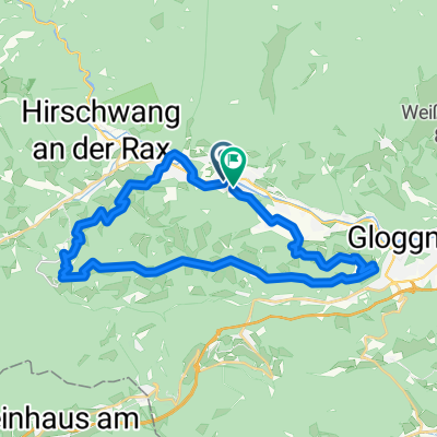
Payerbach - Höllental - Kernhof - Freinsattel - Preiner Gscheid
A cycling route starting in Payerbach, Lower Austria, Austria.
Overview
About this route
- -:--
- Duration
- 160.7 km
- Distance
- 1,525 m
- Ascent
- 1,525 m
- Descent
- ---
- Avg. speed
- ---
- Max. altitude
Continue with Bikemap
Use, edit, or download this cycling route
You would like to ride Payerbach - Höllental - Kernhof - Freinsattel - Preiner Gscheid or customize it for your own trip? Here is what you can do with this Bikemap route:
Free features
- Save this route as favorite or in collections
- Copy & plan your own version of this route
- Split it into stages to create a multi-day tour
- Sync your route with Garmin or Wahoo
Premium features
Free trial for 3 days, or one-time payment. More about Bikemap Premium.
- Navigate this route on iOS & Android
- Export a GPX / KML file of this route
- Create your custom printout (try it for free)
- Download this route for offline navigation
Discover more Premium features.
Get Bikemap PremiumFrom our community
Other popular routes starting in Payerbach
 Rund um die Rax
- Distance
- 126.9 km
- Ascent
- 1,240 m
- Descent
- 1,241 m
- Location
- Payerbach, Lower Austria, Austria
 Trainingsstrecke über Speckbacherhütte
- Distance
- 33.5 km
- Ascent
- 987 m
- Descent
- 987 m
- Location
- Payerbach, Lower Austria, Austria
 Mariazeller-Runde
- Distance
- 146.1 km
- Ascent
- 1,468 m
- Descent
- 1,468 m
- Location
- Payerbach, Lower Austria, Austria
 Payerbach - Höllental - Kernhof - Freinsattel - Preiner Gscheid
- Distance
- 160.7 km
- Ascent
- 1,525 m
- Descent
- 1,525 m
- Location
- Payerbach, Lower Austria, Austria
 Kreuzbergstrecke Gloggnitz
- Distance
- 28.5 km
- Ascent
- 1,099 m
- Descent
- 1,091 m
- Location
- Payerbach, Lower Austria, Austria
 Payerbach - Mürztal - Hainfeld
- Distance
- 124.5 km
- Ascent
- 1,391 m
- Descent
- 1,462 m
- Location
- Payerbach, Lower Austria, Austria
 Kreuzbergstecke vom Bahnhof Payerbach-Reichenau (Ohne Singletrails)
- Distance
- 32.4 km
- Ascent
- 1,143 m
- Descent
- 1,143 m
- Location
- Payerbach, Lower Austria, Austria
 Rec Kreuzbergstrecke + Heimweg
- Distance
- 56.2 km
- Ascent
- 1,184 m
- Descent
- 1,211 m
- Location
- Payerbach, Lower Austria, Austria
Open it in the app