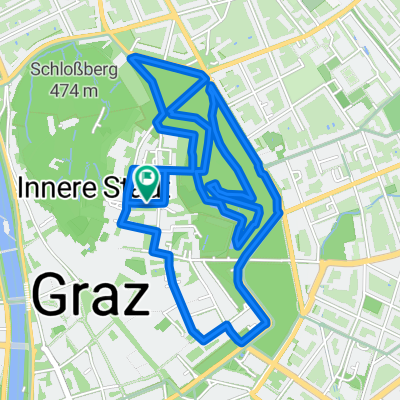
- 5.2 km
- 33 m
- 33 m
- Graz, Styria, Austria
Graz - Thalersee - Göstinger Burg
A cycling route starting in Graz, Styria, Austria.
Overview
About this route
Tolle Route die gemütlich anfängt und nach ca. 2/3 anspruchsvoller wird. Die Wegfindung ist etwas schwierig (speziell wenn man nicht aus der Umgebung ist - so wie ich) aber man wird mit einer tollen Strecke belohnt. Könnte mir auch vorstellen, dass die Route in Gegenrichtung genauso schön ist, allerdings fängt man dann mit dem steilen Stück schon relativ früh an. Achtung: bei feuchtem Wetter eher nicht zu empfehlen, weil die Wege dann schon ziemlich schlammig sind.
- -:--
- Duration
- 29.3 km
- Distance
- 406 m
- Ascent
- 404 m
- Descent
- ---
- Avg. speed
- ---
- Max. altitude
Continue with Bikemap
Use, edit, or download this cycling route
You would like to ride Graz - Thalersee - Göstinger Burg or customize it for your own trip? Here is what you can do with this Bikemap route:
Free features
- Save this route as favorite or in collections
- Copy & plan your own version of this route
- Sync your route with Garmin or Wahoo
Premium features
Free trial for 3 days, or one-time payment. More about Bikemap Premium.
- Navigate this route on iOS & Android
- Export a GPX / KML file of this route
- Create your custom printout (try it for free)
- Download this route for offline navigation
Discover more Premium features.
Get Bikemap PremiumFrom our community
Other popular routes starting in Graz
- Route in Graz
- Kalkleiten - Rinnegg
- 32.4 km
- 821 m
- 808 m
- Graz, Styria, Austria
- Grazathlon 2026 ohne Tummelplatz
- 10.8 km
- 598 m
- 603 m
- Graz, Styria, Austria
- Von Graz bis Triest
- 527 km
- 5,886 m
- 6,234 m
- Graz, Styria, Austria
- Graz - Grado über die Hügel
- 468.9 km
- 10,070 m
- 10,433 m
- Graz, Styria, Austria
- Fölling
- 25.1 km
- 281 m
- 326 m
- Graz, Styria, Austria
- Kumbergrunde
- 43.2 km
- 639 m
- 672 m
- Graz, Styria, Austria
- Schöckl
- 42.4 km
- 1,092 m
- 1,112 m
- Graz, Styria, Austria
Open it in the app


