

TDA - Charleston Ride (Palmer
A cycling route starting in Lobethal, South Australia, Australia.
Overview
About this route
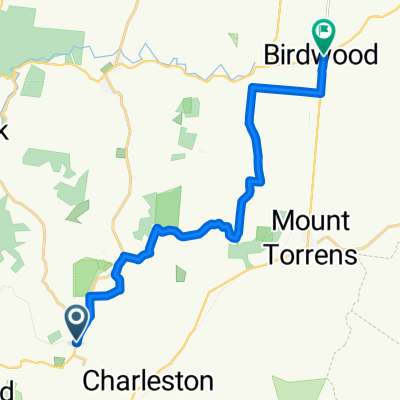
Charleston, Mt Torrens, Birdwood, Tunkilla, Palmer, Tunkilla, Mt Torrens, Charleston
- -:--
- Duration
- 66.6 km
- Distance
- 690 m
- Ascent
- 616 m
- Descent
- ---
- Avg. speed
- 478 m
- Avg. speed

Route quality
Waytypes & surfaces along the route
Waytypes
Busy road
61.1 km
(92 %)
Road
2.9 km
(4 %)
Surfaces
Paved
64.8 km
(97 %)
Unpaved
1.5 km
(2 %)
Asphalt
37.5 km
(56 %)
Paved (undefined)
27.3 km
(41 %)
Continue with Bikemap
Use, edit, or download this cycling route
You would like to ride TDA - Charleston Ride (Palmer or customize it for your own trip? Here is what you can do with this Bikemap route:
Free features
- Save this route as favorite or in collections
- Copy & plan your own version of this route
- Sync your route with Garmin or Wahoo
Premium features
Free trial for 3 days, or one-time payment. More about Bikemap Premium.
- Navigate this route on iOS & Android
- Export a GPX / KML file of this route
- Create your custom printout (try it for free)
- Download this route for offline navigation
Discover more Premium features.
Get Bikemap PremiumFrom our community
Other popular routes starting in Lobethal
 Kona Dirty Weekend 2010
- Distance
- 10.3 km
- Ascent
- 216 m
- Descent
- 217 m
- Location
- Lobethal, South Australia, Australia
 Newman Road 1, Charleston to Newman Road 17, Charleston
- Distance
- 38.4 km
- Ascent
- 458 m
- Descent
- 457 m
- Location
- Lobethal, South Australia, Australia
 TDA - Charleston Ride (Palmer
- Distance
- 66.6 km
- Ascent
- 690 m
- Descent
- 616 m
- Location
- Lobethal, South Australia, Australia
 Jjjdfff
- Distance
- 18 km
- Ascent
- 119 m
- Descent
- 263 m
- Location
- Lobethal, South Australia, Australia
 Lobethal Charleston , Mt Torrens All Sealed
- Distance
- 22.8 km
- Ascent
- 354 m
- Descent
- 354 m
- Location
- Lobethal, South Australia, Australia
 Bike SA Outback Odyssey 2015 Day 2
- Distance
- 74 km
- Ascent
- 496 m
- Descent
- 635 m
- Location
- Lobethal, South Australia, Australia
 Mawson Trail Lobethal to Birdwood
- Distance
- 18.4 km
- Ascent
- 204 m
- Descent
- 230 m
- Location
- Lobethal, South Australia, Australia
 Steep Track Reroute- Cudlee Creek
- Distance
- 0.9 km
- Ascent
- 106 m
- Descent
- 30 m
- Location
- Lobethal, South Australia, Australia
Open it in the app