

Neuffener- und Hülbener Steige
A cycling route starting in Neckartailfingen, Baden-Wurttemberg, Germany.
Overview
About this route
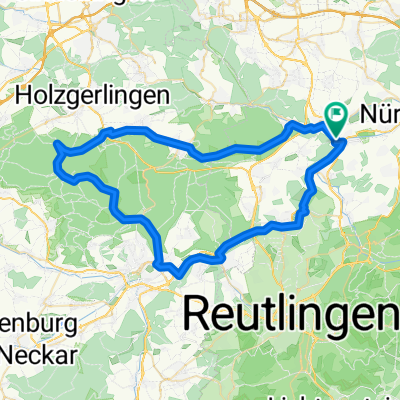
From Neckartailfingen, Altdorf, Großbettlingen, Kohlberg up the Neuffener Steige. Then over Grabenstetten to Urach, Hülben into the Ermstal to Dettingen, Neckartenzlingen and back to Neckartailfingen.
There a refreshing swim in the gravel pit lake.
At the entrance to Hülben "Radlertreff" at Pizzeria Mario.
- -:--
- Duration
- 63.8 km
- Distance
- 1,170 m
- Ascent
- 1,165 m
- Descent
- ---
- Avg. speed
- 718 m
- Max. altitude
Route quality
Waytypes & surfaces along the route
Waytypes
Quiet road
13.4 km
(21 %)
Road
12.8 km
(20 %)
Surfaces
Paved
47.9 km
(75 %)
Unpaved
1.3 km
(2 %)
Asphalt
40.9 km
(64 %)
Paved (undefined)
7 km
(11 %)
Continue with Bikemap
Use, edit, or download this cycling route
You would like to ride Neuffener- und Hülbener Steige or customize it for your own trip? Here is what you can do with this Bikemap route:
Free features
- Save this route as favorite or in collections
- Copy & plan your own version of this route
- Sync your route with Garmin or Wahoo
Premium features
Free trial for 3 days, or one-time payment. More about Bikemap Premium.
- Navigate this route on iOS & Android
- Export a GPX / KML file of this route
- Create your custom printout (try it for free)
- Download this route for offline navigation
Discover more Premium features.
Get Bikemap PremiumFrom our community
Other popular routes starting in Neckartailfingen
 Neckartailfingen - Waldenbuch
- Distance
- 12.6 km
- Ascent
- 217 m
- Descent
- 103 m
- Location
- Neckartailfingen, Baden-Wurttemberg, Germany
 Aich_Dettenhausen_Burkhardsm_Aich
- Distance
- 26.3 km
- Ascent
- 266 m
- Descent
- 266 m
- Location
- Neckartailfingen, Baden-Wurttemberg, Germany
 In den Schönbuch
- Distance
- 63.1 km
- Ascent
- 680 m
- Descent
- 712 m
- Location
- Neckartailfingen, Baden-Wurttemberg, Germany
 bike tour from Neckartailfingen to Unterensingen
- Distance
- 17.5 km
- Ascent
- 115 m
- Descent
- 126 m
- Location
- Neckartailfingen, Baden-Wurttemberg, Germany
 Neckartailfingen-Tübingen-Herrenberg-Weil der Stadt-Neckartailfingen
- Distance
- 115.8 km
- Ascent
- 587 m
- Descent
- 587 m
- Location
- Neckartailfingen, Baden-Wurttemberg, Germany
 Von Neckartailfingen nach Stuttgart-Vaihingen
- Distance
- 44.8 km
- Ascent
- 334 m
- Descent
- 335 m
- Location
- Neckartailfingen, Baden-Wurttemberg, Germany
 Ausfahrt von Neckartailfingen nach Schönaich
- Distance
- 20 km
- Ascent
- 256 m
- Descent
- 112 m
- Location
- Neckartailfingen, Baden-Wurttemberg, Germany
 Neckartailfingen-Rottenburg
- Distance
- 71.2 km
- Ascent
- 353 m
- Descent
- 350 m
- Location
- Neckartailfingen, Baden-Wurttemberg, Germany
Open it in the app