

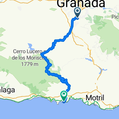
Granada - Salobreña
A cycling route starting in Gójar, Andalusia, Spain.
Overview
About this route
Ruta Granada - Salobreña con el club Granabike.
Un día de perros climatológicamente hablando porque nos ha llovido en cotas altas y hemos pasado un fressski...Por lo demás muy bien, ritmo tranquilo y una pena de no poder disfrutar de los paisajes por las nubes. Un almuerzo en "emilio" en Salobreña con rica paella y cervezas..
- -:--
- Duration
- 86.8 km
- Distance
- 1,071 m
- Ascent
- 1,812 m
- Descent
- ---
- Avg. speed
- ---
- Max. altitude

Continue with Bikemap
Use, edit, or download this cycling route
You would like to ride Granada - Salobreña or customize it for your own trip? Here is what you can do with this Bikemap route:
Free features
- Save this route as favorite or in collections
- Copy & plan your own version of this route
- Split it into stages to create a multi-day tour
- Sync your route with Garmin or Wahoo
Premium features
Free trial for 3 days, or one-time payment. More about Bikemap Premium.
- Navigate this route on iOS & Android
- Export a GPX / KML file of this route
- Create your custom printout (try it for free)
- Download this route for offline navigation
Discover more Premium features.
Get Bikemap PremiumFrom our community
Other popular routes starting in Gójar
 subida al collado del fraile barrancohondao 2012
- Distance
- 27.1 km
- Ascent
- 819 m
- Descent
- 553 m
- Location
- Gójar, Andalusia, Spain
 Granada - Salobreña
- Distance
- 86.8 km
- Ascent
- 1,071 m
- Descent
- 1,812 m
- Location
- Gójar, Andalusia, Spain
 De Gójar al rio Dílar
- Distance
- 21 km
- Ascent
- 340 m
- Descent
- 393 m
- Location
- Gójar, Andalusia, Spain
 LOMA LINDA-GRANADA-GUEJAR SIERRA-DORNAJO-PURCHE-GRANADA
- Distance
- 62.1 km
- Ascent
- 1,264 m
- Descent
- 1,335 m
- Location
- Gójar, Andalusia, Spain
 Rio Dílar
- Distance
- 25.6 km
- Ascent
- 870 m
- Descent
- 803 m
- Location
- Gójar, Andalusia, Spain
 Gójar a Pinos Genil
- Distance
- 43.9 km
- Ascent
- 297 m
- Descent
- 300 m
- Location
- Gójar, Andalusia, Spain
 LOMA LINDA - ALMUÑECAR
- Distance
- 89.9 km
- Ascent
- 1,344 m
- Descent
- 2,088 m
- Location
- Gójar, Andalusia, Spain
 GR209-Collado del Fraile-15/03/09
- Distance
- 23.4 km
- Ascent
- 791 m
- Descent
- 505 m
- Location
- Gójar, Andalusia, Spain
Open it in the app