

kulm runde
A cycling route starting in Stubenberg, Styria, Austria.
Overview
About this route
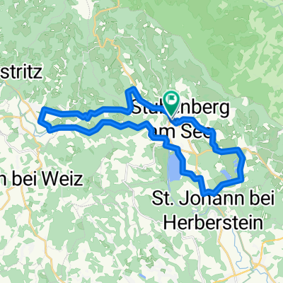
departure from jandl to stubenberg a. see, ascent to kulmwirt, the last meters to the kulm (975m) can only be done on foot, at the top radar station of the federal army, view towards weiz and the surroundings, then descent via hochlangegg and Setzberg to Pischelsdorf, further to Gersdorf, Hirnsdorf, to St. Johann bei Herberstein. From there back up to jandl
travel time approx. 3h
- -:--
- Duration
- 40.1 km
- Distance
- 961 m
- Ascent
- 1,105 m
- Descent
- ---
- Avg. speed
- 961 m
- Max. altitude

Route quality
Waytypes & surfaces along the route
Waytypes
Quiet road
23.3 km
(58 %)
Road
4.4 km
(11 %)
Surfaces
Paved
17.6 km
(44 %)
Unpaved
2.4 km
(6 %)
Asphalt
17.6 km
(44 %)
Gravel
2 km
(5 %)
Continue with Bikemap
Use, edit, or download this cycling route
You would like to ride kulm runde or customize it for your own trip? Here is what you can do with this Bikemap route:
Free features
- Save this route as favorite or in collections
- Copy & plan your own version of this route
- Sync your route with Garmin or Wahoo
Premium features
Free trial for 3 days, or one-time payment. More about Bikemap Premium.
- Navigate this route on iOS & Android
- Export a GPX / KML file of this route
- Create your custom printout (try it for free)
- Download this route for offline navigation
Discover more Premium features.
Get Bikemap PremiumFrom our community
Other popular routes starting in Stubenberg
 Apfellandtour
- Distance
- 64.4 km
- Ascent
- 1,189 m
- Descent
- 1,189 m
- Location
- Stubenberg, Styria, Austria
 pöllauer tal
- Distance
- 67.7 km
- Ascent
- 2,033 m
- Descent
- 1,682 m
- Location
- Stubenberg, Styria, Austria
 Kleine Stubenbergrunde
- Distance
- 29.5 km
- Ascent
- 375 m
- Descent
- 374 m
- Location
- Stubenberg, Styria, Austria
 Stubenergsee-Angern
- Distance
- 26.1 km
- Ascent
- 219 m
- Descent
- 219 m
- Location
- Stubenberg, Styria, Austria
 stubenberg - raab ursprung und retour
- Distance
- 118.4 km
- Ascent
- 2,439 m
- Descent
- 2,557 m
- Location
- Stubenberg, Styria, Austria
 Stubenberg-Runde zur Burg
- Distance
- 22.1 km
- Ascent
- 394 m
- Descent
- 399 m
- Location
- Stubenberg, Styria, Austria
 stubenberg a. see - wien (margareten)
- Distance
- 171.4 km
- Ascent
- 2,493 m
- Descent
- 2,834 m
- Location
- Stubenberg, Styria, Austria
 Apfeland Stubenberg triathlon
- Distance
- 43.6 km
- Ascent
- 442 m
- Descent
- 402 m
- Location
- Stubenberg, Styria, Austria
Open it in the app