pöllauer tal
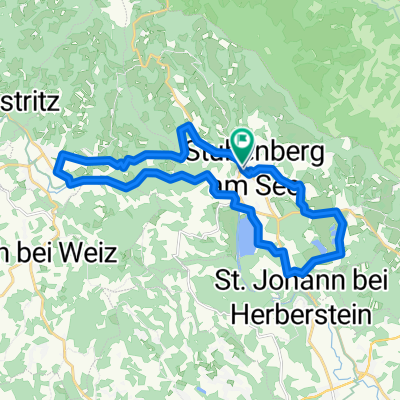
A cycling route starting in Stubenberg, Styria, Austria.
Overview
About this route
departure from seehotel erlaa via haidbichl to the municipality of schönegg, down through various alpine meadows to pöllau (425m), briefly visiting the castle there. then back up to pöllauberg to the pilgrimage church (753m). during the ascent a short not necessarily bike-friendly section marked in green. then back over asphalt roads, always hilly along the valley closure through waldhof muhr and the municipality of sonnhofen to gschaider sattel (807m). continue up and down to mauerhöf (696m), municipality of rabenwald, over the saddle at gabelbauer (891m) back into the feistritztal, short detour up towards buchkogel. down to stelzer lex and back to jandl.
travel time approx. 6h
- -:--
- Duration
- 67.7 km
- Distance
- 2,033 m
- Ascent
- 1,682 m
- Descent
- ---
- Avg. speed
- 927 m
- Max. altitude
Route quality
Waytypes & surfaces along the route
Waytypes
Quiet road
51.4 km
(76 %)
Road
3.4 km
(5 %)
Surfaces
Paved
10.2 km
(15 %)
Unpaved
2 km
(3 %)
Asphalt
10.2 km
(15 %)
Ground
1.4 km
(2 %)
Continue with Bikemap
Use, edit, or download this cycling route
You would like to ride pöllauer tal or customize it for your own trip? Here is what you can do with this Bikemap route:
Free features
- Save this route as favorite or in collections
- Copy & plan your own version of this route
- Sync your route with Garmin or Wahoo
Premium features
Free trial for 3 days, or one-time payment. More about Bikemap Premium.
- Navigate this route on iOS & Android
- Export a GPX / KML file of this route
- Create your custom printout (try it for free)
- Download this route for offline navigation
Discover more Premium features.
Get Bikemap PremiumFrom our community
Other popular routes starting in Stubenberg
- Feistritztal
- Distance
- 19.1 km
- Ascent
- 257 m
- Descent
- 104 m
- Location
- Stubenberg, Styria, Austria
- Apfeland Stubenberg triathlon
- Distance
- 43.6 km
- Ascent
- 442 m
- Descent
- 402 m
- Location
- Stubenberg, Styria, Austria
- stubenberg a. see - wien (margareten)
- Distance
- 171.4 km
- Ascent
- 2,493 m
- Descent
- 2,834 m
- Location
- Stubenberg, Styria, Austria
- stubenberg - raab ursprung und retour
- Distance
- 118.4 km
- Ascent
- 2,439 m
- Descent
- 2,557 m
- Location
- Stubenberg, Styria, Austria
- Stubenergsee-Angern
- Distance
- 26.1 km
- Ascent
- 219 m
- Descent
- 219 m
- Location
- Stubenberg, Styria, Austria
- kulm runde
- Distance
- 40.1 km
- Ascent
- 961 m
- Descent
- 1,105 m
- Location
- Stubenberg, Styria, Austria
- Apfellandtour
- Distance
- 64.4 km
- Ascent
- 1,189 m
- Descent
- 1,189 m
- Location
- Stubenberg, Styria, Austria
- Stubenbergsee - Ackerwirt - Stubenbergsee
- Distance
- 18.4 km
- Ascent
- 459 m
- Descent
- 459 m
- Location
- Stubenberg, Styria, Austria
Open it in the app