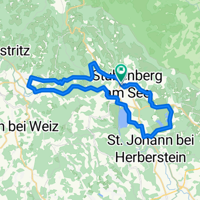
stubenberg - raab ursprung und retour
A cycling route starting in Stubenberg, Styria, Austria.
Overview
About this route
start at around 8 o'clock at jandl, down to st. johann, then onto pischelsdorf. via neudorf, prebuch, wolga and various hills to weiz. from there to the raabtal cycle path which initially runs above the rocks of raabklamm, then south of passail down to raab. then continue along the valley to waldmühle (886m). from there on foot to raabursprung and further up to schwoabauerkreuz (1249m). back to the bike and down the raab valley to arzbach, where I take a quick look at raabklamm. the road over goller sattel is unfortunately closed due to construction work, so I have to return on the other side to weiz. from weiz through krottendorf and etzersdorf to puch. from there down into feistritzklamm, which brings me back to stubenberg. from there the last kilometers back up to jandl. travel time about 8h, plus 1.5h walking time.
- -:--
- Duration
- 118.4 km
- Distance
- 2,439 m
- Ascent
- 2,557 m
- Descent
- ---
- Avg. speed
- 903 m
- Max. altitude
Route quality
Waytypes & surfaces along the route
Waytypes
Quiet road
54.5 km
(46 %)
Road
39.1 km
(33 %)
Surfaces
Paved
80.5 km
(68 %)
Unpaved
5.9 km
(5 %)
Asphalt
80.5 km
(68 %)
Gravel
3.6 km
(3 %)
Continue with Bikemap
Use, edit, or download this cycling route
You would like to ride stubenberg - raab ursprung und retour or customize it for your own trip? Here is what you can do with this Bikemap route:
Free features
- Save this route as favorite or in collections
- Copy & plan your own version of this route
- Split it into stages to create a multi-day tour
- Sync your route with Garmin or Wahoo
Premium features
Free trial for 3 days, or one-time payment. More about Bikemap Premium.
- Navigate this route on iOS & Android
- Export a GPX / KML file of this route
- Create your custom printout (try it for free)
- Download this route for offline navigation
Discover more Premium features.
Get Bikemap PremiumFrom our community
Other popular routes starting in Stubenberg
- Apfellandtour
- Distance
- 64.4 km
- Ascent
- 1,189 m
- Descent
- 1,189 m
- Location
- Stubenberg, Styria, Austria
- Apfeland Stubenberg triathlon
- Distance
- 43.6 km
- Ascent
- 442 m
- Descent
- 402 m
- Location
- Stubenberg, Styria, Austria
- Kleine Stubenbergrunde
- Distance
- 29.5 km
- Ascent
- 375 m
- Descent
- 374 m
- Location
- Stubenberg, Styria, Austria
- Stubenergsee-Angern
- Distance
- 26.1 km
- Ascent
- 219 m
- Descent
- 219 m
- Location
- Stubenberg, Styria, Austria
- Apfelland Triathlon Radstrecke (Olymp. Dist.)
- Distance
- 35.4 km
- Ascent
- 428 m
- Descent
- 426 m
- Location
- Stubenberg, Styria, Austria
- pöllauer tal
- Distance
- 67.7 km
- Ascent
- 2,033 m
- Descent
- 1,682 m
- Location
- Stubenberg, Styria, Austria
- Feistritztal
- Distance
- 19.1 km
- Ascent
- 257 m
- Descent
- 104 m
- Location
- Stubenberg, Styria, Austria
- Stubenbergsee - Ackerwirt - Stubenbergsee
- Distance
- 18.4 km
- Ascent
- 459 m
- Descent
- 459 m
- Location
- Stubenberg, Styria, Austria
Open it in the app