Pętla Leszczyny-Rudy-Rybnik-Leszczyny
A cycling route starting in Stanowice, Silesian Voivodeship, Poland.
Overview
About this route
The route runs 80% on gravel roads, about 50% of the route through the forest. Along the way, we pass the narrow-gauge railway station in Rudach Raciborskich, the dam, and the Rybnicki reservoir.
- -:--
- Duration
- 44.2 km
- Distance
- 173 m
- Ascent
- 170 m
- Descent
- ---
- Avg. speed
- ---
- Max. altitude
Route quality
Waytypes & surfaces along the route
Waytypes
Quiet road
17.7 km
(40 %)
Track
13.7 km
(31 %)
Surfaces
Paved
16.4 km
(37 %)
Unpaved
22.1 km
(50 %)
Asphalt
13.7 km
(31 %)
Gravel
13.3 km
(30 %)
Continue with Bikemap
Use, edit, or download this cycling route
You would like to ride Pętla Leszczyny-Rudy-Rybnik-Leszczyny or customize it for your own trip? Here is what you can do with this Bikemap route:
Free features
- Save this route as favorite or in collections
- Copy & plan your own version of this route
- Sync your route with Garmin or Wahoo
Premium features
Free trial for 3 days, or one-time payment. More about Bikemap Premium.
- Navigate this route on iOS & Android
- Export a GPX / KML file of this route
- Create your custom printout (try it for free)
- Download this route for offline navigation
Discover more Premium features.
Get Bikemap PremiumFrom our community
Other popular routes starting in Stanowice
Pętla Leszczyny- Lasy Rudzkie-Leszczyny- Distance
- 75.6 km
- Ascent
- 202 m
- Descent
- 201 m
- Location
- Stanowice, Silesian Voivodeship, Poland
Pętla Leszczyny-Bujaków-Gostyń-Palowice-Leszczyny- Distance
- 58.3 km
- Ascent
- 232 m
- Descent
- 232 m
- Location
- Stanowice, Silesian Voivodeship, Poland
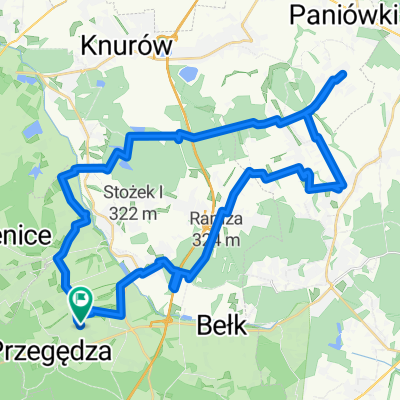
Pętla Leszczyny- Ramża-Palowice-Żory-Leszczyny- Distance
- 44.5 km
- Ascent
- 181 m
- Descent
- 181 m
- Location
- Stanowice, Silesian Voivodeship, Poland
Pętla Leszczyny dwie zapory Goczałkowice - Łąka- Distance
- 103.1 km
- Ascent
- 202 m
- Descent
- 201 m
- Location
- Stanowice, Silesian Voivodeship, Poland
Powstańców 17, Stanowice do Czynu Społecznego 8, Stanowice- Distance
- 20.8 km
- Ascent
- 79 m
- Descent
- 112 m
- Location
- Stanowice, Silesian Voivodeship, Poland
Pętla Leszczyny-Rudy-Rybnik-Leszczyny- Distance
- 44.2 km
- Ascent
- 173 m
- Descent
- 170 m
- Location
- Stanowice, Silesian Voivodeship, Poland
Leszczyny- Palowice-Szczejkowice-Leszczyny- Distance
- 43 km
- Ascent
- 207 m
- Descent
- 204 m
- Location
- Stanowice, Silesian Voivodeship, Poland
Leszczyny- Strumień-Pszczyna-Żory-Leszczyny- Distance
- 86.6 km
- Ascent
- 160 m
- Descent
- 160 m
- Location
- Stanowice, Silesian Voivodeship, Poland
Open it in the app

