Leszczyny- Palowice-Szczejkowice-Leszczyny
A cycling route starting in Stanowice, Silesian Voivodeship, Poland.
Overview
About this route
Trasa w 70% przebiega przez okoliczne lasy, wzdłuż stawów łańcuchowych w Palowicach, zabytkowego pieca hutniczego oraz w poblizu dwóch żródełek wody w Szczejkowicach, dodatowo Ramża w Dębieńsku
- -:--
- Duration
- 43 km
- Distance
- 207 m
- Ascent
- 204 m
- Descent
- ---
- Avg. speed
- ---
- Avg. speed
Route quality
Waytypes & surfaces along the route
Waytypes
Track
14.6 km
(34 %)
Road
13.2 km
(31 %)
Surfaces
Paved
17 km
(39 %)
Unpaved
13 km
(30 %)
Asphalt
13.9 km
(32 %)
Gravel
6.2 km
(14 %)
Continue with Bikemap
Use, edit, or download this cycling route
You would like to ride Leszczyny- Palowice-Szczejkowice-Leszczyny or customize it for your own trip? Here is what you can do with this Bikemap route:
Free features
- Save this route as favorite or in collections
- Copy & plan your own version of this route
- Sync your route with Garmin or Wahoo
Premium features
Free trial for 3 days, or one-time payment. More about Bikemap Premium.
- Navigate this route on iOS & Android
- Export a GPX / KML file of this route
- Create your custom printout (try it for free)
- Download this route for offline navigation
Discover more Premium features.
Get Bikemap PremiumFrom our community
Other popular routes starting in Stanowice
- Pętla Leszczyny-Rudy-Rybnik-Leszczyny
- Distance
- 44.2 km
- Ascent
- 173 m
- Descent
- 170 m
- Location
- Stanowice, Silesian Voivodeship, Poland
- Leśna 21, Przegędza do Leśna 21, Przegędza
- Distance
- 32.2 km
- Ascent
- 339 m
- Descent
- 331 m
- Location
- Stanowice, Silesian Voivodeship, Poland
- Leszczyny- Strumień-Pszczyna-Żory-Leszczyny
- Distance
- 86.6 km
- Ascent
- 160 m
- Descent
- 160 m
- Location
- Stanowice, Silesian Voivodeship, Poland
- Powstańców 17, Stanowice do Czynu Społecznego 8, Stanowice
- Distance
- 20.8 km
- Ascent
- 79 m
- Descent
- 112 m
- Location
- Stanowice, Silesian Voivodeship, Poland
- Leszczyny- Palowice-Szczejkowice-Leszczyny
- Distance
- 43 km
- Ascent
- 207 m
- Descent
- 204 m
- Location
- Stanowice, Silesian Voivodeship, Poland
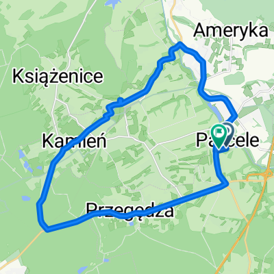
- Pętla Leszczyny- Ramża-Palowice-Żory-Leszczyny
- Distance
- 44.5 km
- Ascent
- 181 m
- Descent
- 181 m
- Location
- Stanowice, Silesian Voivodeship, Poland
- Pętla Leszczyny- Lasy Rudzkie-Leszczyny
- Distance
- 75.6 km
- Ascent
- 202 m
- Descent
- 201 m
- Location
- Stanowice, Silesian Voivodeship, Poland
- Pętla Leszczyny dwie zapory Goczałkowice - Łąka
- Distance
- 103.1 km
- Ascent
- 202 m
- Descent
- 201 m
- Location
- Stanowice, Silesian Voivodeship, Poland
Open it in the app