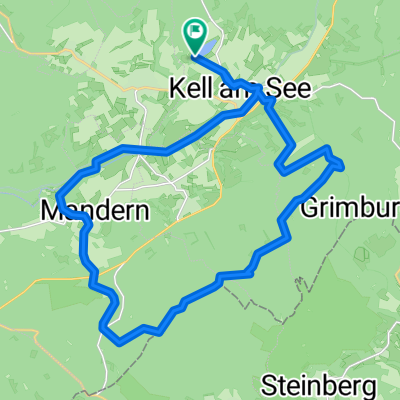
Feierabenrroute Kell Schillingen See Heddert Kell
A cycling route starting in Kell am See, Rhineland-Palatinate, Germany.
Overview
About this route
Schöne Route von Kell am Feriendorf vorbei durch den Wald nach Heddert ( Sportplatz Schillingen ) am Schillinger See vorbei über schöne Schotterwege zum Ruwer Hochwald Radweg bis nach Kell.Weiter über Radweg Richtung Reinsfeld bis zum ehem. Bahnübergang Tonnenwäldchen dort links ab über geteerten Wirtschaftsweg zurück nach Kell, in der Ruwerstraße rechts zur Baumschule Marx von dort zurück zum Stausee vorbei am Fronhof wieder nach Kell.
Dauer ca. 2 Stunden
- -:--
- Duration
- 23.2 km
- Distance
- 255 m
- Ascent
- 210 m
- Descent
- ---
- Avg. speed
- 546 m
- Max. altitude
Route quality
Waytypes & surfaces along the route
Waytypes
Track
13.7 km
(59 %)
Path
6.7 km
(29 %)
Surfaces
Paved
15.6 km
(67 %)
Unpaved
7.4 km
(32 %)
Asphalt
13 km
(56 %)
Gravel
5.3 km
(23 %)
Continue with Bikemap
Use, edit, or download this cycling route
You would like to ride Feierabenrroute Kell Schillingen See Heddert Kell or customize it for your own trip? Here is what you can do with this Bikemap route:
Free features
- Save this route as favorite or in collections
- Copy & plan your own version of this route
- Sync your route with Garmin or Wahoo
Premium features
Free trial for 3 days, or one-time payment. More about Bikemap Premium.
- Navigate this route on iOS & Android
- Export a GPX / KML file of this route
- Create your custom printout (try it for free)
- Download this route for offline navigation
Discover more Premium features.
Get Bikemap PremiumFrom our community
Other popular routes starting in Kell am See
- Kell-Aach
- Distance
- 32.8 km
- Ascent
- 715 m
- Descent
- 928 m
- Location
- Kell am See, Rhineland-Palatinate, Germany
- Kell am See - Saarburg
- Distance
- 26.5 km
- Ascent
- 173 m
- Descent
- 491 m
- Location
- Kell am See, Rhineland-Palatinate, Germany
- Hunsrück
- Distance
- 416.6 km
- Ascent
- 991 m
- Descent
- 991 m
- Location
- Kell am See, Rhineland-Palatinate, Germany
- L143, Kell am See to Dörnerstraße 13–17, Reinsfeld
- Distance
- 8.4 km
- Ascent
- 109 m
- Descent
- 61 m
- Location
- Kell am See, Rhineland-Palatinate, Germany
- oude spoorlijn
- Distance
- 36.5 km
- Ascent
- 170 m
- Descent
- 532 m
- Location
- Kell am See, Rhineland-Palatinate, Germany
- Seeuferweg 1, Kell am See nach Hochwaldstraße 1, Kell am See
- Distance
- 1.7 km
- Ascent
- 15 m
- Descent
- 7 m
- Location
- Kell am See, Rhineland-Palatinate, Germany
- Tour 12c, Kell am See 5 Wie
- Distance
- 2 km
- Ascent
- 29 m
- Descent
- 26 m
- Location
- Kell am See, Rhineland-Palatinate, Germany
- kell am see
- Distance
- 9.8 km
- Ascent
- 168 m
- Descent
- 135 m
- Location
- Kell am See, Rhineland-Palatinate, Germany
Open it in the app