

Armidale, Uralla, Gostwyck loop
A cycling route starting in Armidale, New South Wales, Australia.
Overview
About this route
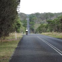
A lovely half-day coffee ride on quiet, scenic and mostly sealed roads. Head out of town on Bundarra road, turning at about 15 km towards Invergowrie. At Invergowrie there is a small shop selling coffee, but its too early to stop yet. Bundarra Rd has some fast traffic and lacks a shoulder so we avoid it at the busiest times (~9 am or 5 pm). There is a quieter/hillier alternative route via Booroolong Rd/Dumaresq Rd. Once off Bundarra rd there is generally very little traffic and the route is very scenic. Thunderbolts way has a great swooping downhill, which if taken at maximum speed can get you most of the way up the other side. Uralla has a great choice of cafes, so a stop is compulsory. It is possible to head back to Armidale via Barley fields Rd and join up with the outward route on Rocky River/Hawthorne drive corner. However, the route mapped here is more interesting (and about 10 km longer). Heading out of Uralla along Gostwyck rd involves a little climbing before you are on a ridge with fabulous views. There is then a long descent down to Gostwyck station and the picturesque Gostwyck chapel, DRG woolshed. There is a ~8 km section of dirt along Gostwyck Rd/Mihi Rd. This can get a bit bumpy when not recently graded. However, we regularly do this ride on road bikes. The seal is reached again at Enmore Rd for a very pleasant if a bit hilly ride back to Armidale. All roads on the return trip are very quiet.
- -:--
- Duration
- 80.3 km
- Distance
- 516 m
- Ascent
- 515 m
- Descent
- ---
- Avg. speed
- ---
- Max. altitude

Route quality
Waytypes & surfaces along the route
Waytypes
Road
43.4 km
(54 %)
Quiet road
24.1 km
(30 %)
Surfaces
Paved
71.5 km
(89 %)
Unpaved
7.2 km
(9 %)
Asphalt
71.5 km
(89 %)
Unpaved (undefined)
6.4 km
(8 %)
Continue with Bikemap
Use, edit, or download this cycling route
You would like to ride Armidale, Uralla, Gostwyck loop or customize it for your own trip? Here is what you can do with this Bikemap route:
Free features
- Save this route as favorite or in collections
- Copy & plan your own version of this route
- Split it into stages to create a multi-day tour
- Sync your route with Garmin or Wahoo
Premium features
Free trial for 3 days, or one-time payment. More about Bikemap Premium.
- Navigate this route on iOS & Android
- Export a GPX / KML file of this route
- Create your custom printout (try it for free)
- Download this route for offline navigation
Discover more Premium features.
Get Bikemap PremiumFrom our community
Other popular routes starting in Armidale
 New England Cycle Trail South
- Distance
- 353.4 km
- Ascent
- 999 m
- Descent
- 1,577 m
- Location
- Armidale, New South Wales, Australia
 Apple tree drive loop for kids
- Distance
- 7.8 km
- Ascent
- 92 m
- Descent
- 93 m
- Location
- Armidale, New South Wales, Australia
 Kelly's plains circuit
- Distance
- 19.5 km
- Ascent
- 179 m
- Descent
- 179 m
- Location
- Armidale, New South Wales, Australia
 Avoiding the Waterfall Way from Armidale
- Distance
- 92.5 km
- Ascent
- 708 m
- Descent
- 708 m
- Location
- Armidale, New South Wales, Australia
 Armidale to Point Lookout loop
- Distance
- 226.3 km
- Ascent
- 4,225 m
- Descent
- 4,225 m
- Location
- Armidale, New South Wales, Australia
 Armidale, Toms Gully, Puddledock loop
- Distance
- 71.6 km
- Ascent
- 607 m
- Descent
- 607 m
- Location
- Armidale, New South Wales, Australia
 Armidale to Gara river crossing along Herbert Park Rd
- Distance
- 48.3 km
- Ascent
- 516 m
- Descent
- 515 m
- Location
- Armidale, New South Wales, Australia
 Armidale Tourist Information Centre to Dangars Gorge return
- Distance
- 47 km
- Ascent
- 355 m
- Descent
- 353 m
- Location
- Armidale, New South Wales, Australia
Open it in the app