

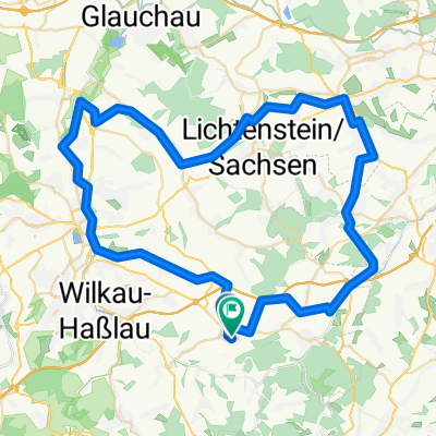
Bahnhof Wiesenburg/Sa. - Ziegelteich (MTB)
A cycling route starting in Wildenfels, Saxony, Germany.
Overview
About this route
Eien mittelschwere, aber nicht ganz anspruchslose Strecke am Nordrand des Erzgebirges für MTB.
Es sit sozusagen meine Haus- und Trainigsstrecke.
Nicht so gut nach nassem Wetter zu fahren, die Abfahrt im Ölbachgrund ist dann mies. Dafür empfehle ich die Variante Bahnhof "Wiesenburg/Sa. - Ziegelteich (Cityrad)"
Weite Strecken führen duch Wald; zwischendurch gibt es schöne Aussichten.
Knifflig sind mal ca. 150 m Abfahrt durch steiles, unbefestigtes Gelände im Ölbachgrund - Hintern runter vom Sattel und über das Hinterrad gehalten - dann geht das auch.
Viel Spaß
- -:--
- Duration
- 18.9 km
- Distance
- 308 m
- Ascent
- 308 m
- Descent
- ---
- Avg. speed
- ---
- Max. altitude
Route quality
Waytypes & surfaces along the route
Waytypes
Road
7.2 km
(38 %)
Quiet road
5.7 km
(30 %)
Surfaces
Paved
9.3 km
(49 %)
Unpaved
5.2 km
(27 %)
Asphalt
6.8 km
(36 %)
Unpaved (undefined)
3.2 km
(17 %)
Continue with Bikemap
Use, edit, or download this cycling route
You would like to ride Bahnhof Wiesenburg/Sa. - Ziegelteich (MTB) or customize it for your own trip? Here is what you can do with this Bikemap route:
Free features
- Save this route as favorite or in collections
- Copy & plan your own version of this route
- Sync your route with Garmin or Wahoo
Premium features
Free trial for 3 days, or one-time payment. More about Bikemap Premium.
- Navigate this route on iOS & Android
- Export a GPX / KML file of this route
- Create your custom printout (try it for free)
- Download this route for offline navigation
Discover more Premium features.
Get Bikemap PremiumFrom our community
Other popular routes starting in Wildenfels
 Lindenallee nach Lindenallee
- Distance
- 188.3 km
- Ascent
- 788 m
- Descent
- 840 m
- Location
- Wildenfels, Saxony, Germany
 Lindenallee 30, Wildenfels nach Lindenallee 45, Wildenfels
- Distance
- 12.6 km
- Ascent
- 271 m
- Descent
- 313 m
- Location
- Wildenfels, Saxony, Germany
 Lindenallee nach Lindenallee
- Distance
- 0.5 km
- Ascent
- 43 m
- Descent
- 47 m
- Location
- Wildenfels, Saxony, Germany
 Auersberg-Tour 01
- Distance
- 65.8 km
- Ascent
- 1,274 m
- Descent
- 1,090 m
- Location
- Wildenfels, Saxony, Germany
 Kirchberg-Irfersgrün-Treuen
- Distance
- 29.2 km
- Ascent
- 499 m
- Descent
- 326 m
- Location
- Wildenfels, Saxony, Germany
 Schulberg 4, Wildenfels nach Schulberg 4, Wildenfels
- Distance
- 22.1 km
- Ascent
- 380 m
- Descent
- 381 m
- Location
- Wildenfels, Saxony, Germany
 Hermannsdorfer Straße 62, Langenweißbach nach Falkenweg 8, Langenweißbach
- Distance
- 7.3 km
- Ascent
- 186 m
- Descent
- 176 m
- Location
- Wildenfels, Saxony, Germany
 Hermannsdorfer Straße 62, Langenweißbach nach Falkenweg 8, Langenweißbach
- Distance
- 29.7 km
- Ascent
- 522 m
- Descent
- 530 m
- Location
- Wildenfels, Saxony, Germany
Open it in the app