
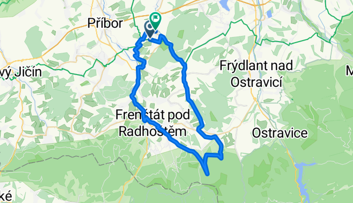
Hukvaldská magistrála II. (Onřejník, Stolová, Nořící hora)
A cycling route starting in Fryčovice, Moravskoslezský kraj, Czechia.
Overview
About this route
Easy start on asphalt, then passing at the foot of Ondřejník along a meadow path with a beautiful view, in Kunčice p./O. the climb begins, turning into a steeper ascent. Once we reach the contour line at Stolové, a pleasant descent follows along the contour line towards Trojanovice, which we will interrupt with a gentle climb along the Bystrý stream, where you can refresh yourselves. Along the way, there is a wonderful view of the surroundings. The route to the finish then combines paved and unpaved roads. We finish the final steep climb with a beautiful view of the surroundings; in good weather you can even see the Jeseníky Mountains. The goal is the local brewery in Dolní Sklenov :-)
- -:--
- Duration
- 45.3 km
- Distance
- 694 m
- Ascent
- 739 m
- Descent
- ---
- Avg. speed
- ---
- Max. altitude

Route quality
Waytypes & surfaces along the route
Waytypes
Track
14.5 km
(32 %)
Quiet road
13.1 km
(29 %)
Surfaces
Paved
23.1 km
(51 %)
Unpaved
9.1 km
(20 %)
Asphalt
17.2 km
(38 %)
Paved (undefined)
5.4 km
(12 %)
Route highlights
Points of interest along the route
\"")
Point of interest after 19.2 km
pohled na Ondřejník
\"")
Point of interest after 21.5 km
Bystrý potok
\"")
Point of interest after 43.9 km
Fojtový vrchy
Continue with Bikemap
Use, edit, or download this cycling route
You would like to ride Hukvaldská magistrála II. (Onřejník, Stolová, Nořící hora) or customize it for your own trip? Here is what you can do with this Bikemap route:
Free features
- Save this route as favorite or in collections
- Copy & plan your own version of this route
- Sync your route with Garmin or Wahoo
Premium features
Free trial for 3 days, or one-time payment. More about Bikemap Premium.
- Navigate this route on iOS & Android
- Export a GPX / KML file of this route
- Create your custom printout (try it for free)
- Download this route for offline navigation
Discover more Premium features.
Get Bikemap PremiumFrom our community
Other popular routes starting in Fryčovice
 Kubánkov
- Distance
- 5.6 km
- Ascent
- 435 m
- Descent
- 111 m
- Location
- Fryčovice, Moravskoslezský kraj, Czechia
 Hukvaldská magistrála II. (Onřejník, Stolová, Nořící hora)
- Distance
- 45.3 km
- Ascent
- 694 m
- Descent
- 739 m
- Location
- Fryčovice, Moravskoslezský kraj, Czechia
 V. Hukvaldská magistrála
- Distance
- 47.2 km
- Ascent
- 342 m
- Descent
- 371 m
- Location
- Fryčovice, Moravskoslezský kraj, Czechia
 Smrk
Smrk- Distance
- 64.8 km
- Ascent
- 1,224 m
- Descent
- 1,221 m
- Location
- Fryčovice, Moravskoslezský kraj, Czechia
 Hukvaldská magistrála IV.
- Distance
- 46.1 km
- Ascent
- 929 m
- Descent
- 893 m
- Location
- Fryčovice, Moravskoslezský kraj, Czechia
 Hukvaldská magistrála III.
- Distance
- 57.6 km
- Ascent
- 916 m
- Descent
- 906 m
- Location
- Fryčovice, Moravskoslezský kraj, Czechia
 Toure de Ukvaldy
- Distance
- 64.5 km
- Ascent
- 1,094 m
- Descent
- 1,129 m
- Location
- Fryčovice, Moravskoslezský kraj, Czechia
 Mlynářská časovka
- Distance
- 30.6 km
- Ascent
- 137 m
- Descent
- 183 m
- Location
- Fryčovice, Moravskoslezský kraj, Czechia
Open it in the app