
Rennradtour 4: Drei-Länder-Tour - Julische Alpen
A cycling route starting in Arnoldstein, Carinthia, Austria.
Overview
About this route
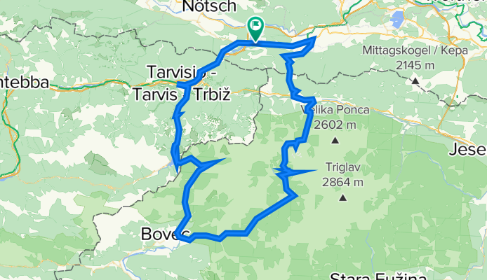
Start in Arnoldstein. Auf der Bundesstraße nach Tarvisio in Italien. Steigung hinauf zum Predil-Pass. Grenzübergang nach Slowenien. Abfahrt ins Soca-Tal. Anfahrt zum Vrsic-Pass (steiler Anstieg!), Abfahrt nach Kranjska Gora (Ski-Weltcup-Ort), kurze Flachpassage nach Podkoren und Auffahrt auf den Wurzenpass, Grenzübertritt nach Österreich/Kärnten. Über Pöckau retour zum Ausgangspunkt Arnoldstein.
- -:--
- Duration
- 105.7 km
- Distance
- 3,304 m
- Ascent
- 3,098 m
- Descent
- ---
- Avg. speed
- 1,625 m
- Max. altitude

Route quality
Waytypes & surfaces along the route
Waytypes
Busy road
85.9 km
(81 %)
Cycleway
9.6 km
(9 %)
Surfaces
Paved
97.2 km
(92 %)
Unpaved
0.3 km
(<1 %)
Asphalt
96.3 km
(91 %)
Paved (undefined)
0.7 km
(<1 %)
Continue with Bikemap
Use, edit, or download this cycling route
You would like to ride Rennradtour 4: Drei-Länder-Tour - Julische Alpen or customize it for your own trip? Here is what you can do with this Bikemap route:
Free features
- Save this route as favorite or in collections
- Copy & plan your own version of this route
- Split it into stages to create a multi-day tour
- Sync your route with Garmin or Wahoo
Premium features
Free trial for 3 days, or one-time payment. More about Bikemap Premium.
- Navigate this route on iOS & Android
- Export a GPX / KML file of this route
- Create your custom printout (try it for free)
- Download this route for offline navigation
Discover more Premium features.
Get Bikemap PremiumFrom our community
Other popular routes starting in Arnoldstein
 Friedhofsallee, Arnoldstein a Gemeindeplatz 4, Arnoldstein
- Distance
- 20.3 km
- Ascent
- 277 m
- Descent
- 262 m
- Location
- Arnoldstein, Carinthia, Austria
 Riegersdorf Tarvisio Resiutta Zaga Kobarid
- Distance
- 105.7 km
- Ascent
- 1,187 m
- Descent
- 1,486 m
- Location
- Arnoldstein, Carinthia, Austria
 Arnoldstein nach Piazza Municipio 8, Venzone
- Distance
- 71.4 km
- Ascent
- 1,353 m
- Descent
- 1,685 m
- Location
- Arnoldstein, Carinthia, Austria
 complete
- Distance
- 695.7 km
- Ascent
- 14,460 m
- Descent
- 14,970 m
- Location
- Arnoldstein, Carinthia, Austria
 Friedhofsallee, Arnoldstein a Friedhofsallee 2, Arnoldstein
- Distance
- 17.8 km
- Ascent
- 331 m
- Descent
- 320 m
- Location
- Arnoldstein, Carinthia, Austria
 Arnoldstein - Udine 2016
- Distance
- 118.8 km
- Ascent
- 357 m
- Descent
- 951 m
- Location
- Arnoldstein, Carinthia, Austria
 Percorso recuperato
- Distance
- 35.9 km
- Ascent
- 238 m
- Descent
- 318 m
- Location
- Arnoldstein, Carinthia, Austria
 Alpe Adria Radweg #1: Arnoldstein - Moggio Udinese
- Distance
- 64.9 km
- Ascent
- 437 m
- Descent
- 706 m
- Location
- Arnoldstein, Carinthia, Austria
Open it in the app