

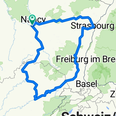
Nancy-Vaison La Romaine 876km
A cycling route starting in Richardménil, Grand Est, France.
Overview
About this route
- -:--
- Duration
- 875.9 km
- Distance
- 2,217 m
- Ascent
- 2,227 m
- Descent
- ---
- Avg. speed
- ---
- Max. altitude

Route quality
Waytypes & surfaces along the route
Waytypes
Road
297.8 km
(34 %)
Quiet road
175.2 km
(20 %)
Surfaces
Paved
402.9 km
(46 %)
Unpaved
35 km
(4 %)
Asphalt
385.4 km
(44 %)
Gravel
26.3 km
(3 %)
Continue with Bikemap
Use, edit, or download this cycling route
You would like to ride Nancy-Vaison La Romaine 876km or customize it for your own trip? Here is what you can do with this Bikemap route:
Free features
- Save this route as favorite or in collections
- Copy & plan your own version of this route
- Split it into stages to create a multi-day tour
- Sync your route with Garmin or Wahoo
Premium features
Free trial for 3 days, or one-time payment. More about Bikemap Premium.
- Navigate this route on iOS & Android
- Export a GPX / KML file of this route
- Create your custom printout (try it for free)
- Download this route for offline navigation
Discover more Premium features.
Get Bikemap PremiumFrom our community
Other popular routes starting in Richardménil
 D570, Richardménil to 2 Rue du Général Patton, Laneuveville-devant-Nancy
- Distance
- 8.8 km
- Ascent
- 83 m
- Descent
- 119 m
- Location
- Richardménil, Grand Est, France
 Saone-Doubs-Alsace-Strabourg-Nancy 2
- Distance
- 670.5 km
- Ascent
- 4,175 m
- Descent
- 4,162 m
- Location
- Richardménil, Grand Est, France
 Richardménil-Anjeux
- Distance
- 111.8 km
- Ascent
- 275 m
- Descent
- 259 m
- Location
- Richardménil, Grand Est, France
 flavigny pontailler
- Distance
- 238.6 km
- Ascent
- 425 m
- Descent
- 464 m
- Location
- Richardménil, Grand Est, France
 Itinéraire modéré en Richardménil
- Distance
- 9.4 km
- Ascent
- 129 m
- Descent
- 141 m
- Location
- Richardménil, Grand Est, France
 Nancy-Vaison La Romaine 876km
- Distance
- 875.9 km
- Ascent
- 2,217 m
- Descent
- 2,227 m
- Location
- Richardménil, Grand Est, France
 De D115, Richardménil à 8 Allée des Tilleuls, Heillecourt
- Distance
- 6.7 km
- Ascent
- 83 m
- Descent
- 64 m
- Location
- Richardménil, Grand Est, France
 De 52 Rue de Nancy, Richardménil à 1 Rue de la Manique, Neuviller-sur-Moselle
- Distance
- 15.6 km
- Ascent
- 72 m
- Descent
- 70 m
- Location
- Richardménil, Grand Est, France
Open it in the app