Etapa6-Prades-Taulis-Ceret-Prunet-Bouleterme-Prades
- 124.7 km
- 2,844 m
- 2,851 m
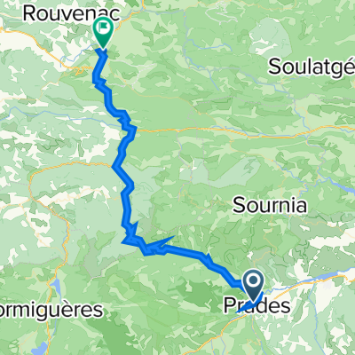
- Prades, Occitanie, France
A cycling route starting in Prades, Occitanie, France.
Overview
Distance: 92.1 km (57.2 mi)
Difficulty: High
Time: 8 - 9 hours
Climbs: 4
Meters/Feet Climbed: 2907 m (9537 ft)
Max/Min Altitude: 1999 / 333 m (6558 / 1092 ft)
Average Grade: 3.08%
Percent Climb Distance: 53%
Climb #1
Distance: 22.2 km (13.8 mi)
Elevation Gain: 1253 m (4111 ft)
Average Slope: 5.63%
Climb #2
Distance: 7.7 km (4.8 mi)
Elevation Gain: 416 m (1365 ft)
Average Slope: 5.41%
Climb #3
Distance: 2.2 km (1.4 mi)
Elevation Gain: 138 m (453 ft)
Average Slope: 6.18%
Climb #4
Distance: 16.7 km (10.4 mi)
Elevation Gain: 1243 m (4078 ft)
Average Slope: 7.44%
created this 12 years ago
Route quality
Quiet road
4.6 km
(5 %)
Road
1.8 km
(2 %)
Paved
25.8 km
(28 %)
Asphalt
25.8 km
(28 %)
Undefined
66.3 km
(72 %)
Continue with Bikemap
You would like to ride FR Riding the Pyrenees 3.0 - Prades to Ax-les-Thermes or customize it for your own trip? Here is what you can do with this Bikemap route:
Free trial for 3 days, or one-time payment. More about Bikemap Premium.
Discover more Premium features.
Get Bikemap PremiumFrom our community
Open it in the app