

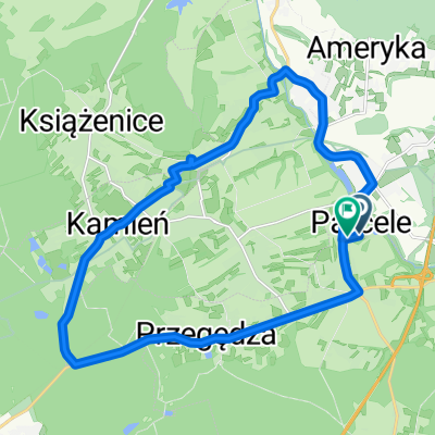
Pętla Leszczyny dwie zapory Goczałkowice - Łąka
A cycling route starting in Stanowice, Silesian Voivodeship, Poland.
Overview
About this route
Two reservoirs in Goczałkowice and in Łąka (Łąka Lake), as well as Pszczyna and the spa park in Goczałkowice Zdrój. 95% of the route is asphalted.
- -:--
- Duration
- 103.1 km
- Distance
- 202 m
- Ascent
- 201 m
- Descent
- ---
- Avg. speed
- ---
- Max. altitude
Route quality
Waytypes & surfaces along the route
Waytypes
Quiet road
24.8 km
(24 %)
Road
16.5 km
(16 %)
Surfaces
Paved
78.4 km
(76 %)
Unpaved
4.1 km
(4 %)
Asphalt
77.4 km
(75 %)
Ground
3.1 km
(3 %)
Continue with Bikemap
Use, edit, or download this cycling route
You would like to ride Pętla Leszczyny dwie zapory Goczałkowice - Łąka or customize it for your own trip? Here is what you can do with this Bikemap route:
Free features
- Save this route as favorite or in collections
- Copy & plan your own version of this route
- Split it into stages to create a multi-day tour
- Sync your route with Garmin or Wahoo
Premium features
Free trial for 3 days, or one-time payment. More about Bikemap Premium.
- Navigate this route on iOS & Android
- Export a GPX / KML file of this route
- Create your custom printout (try it for free)
- Download this route for offline navigation
Discover more Premium features.
Get Bikemap PremiumFrom our community
Other popular routes starting in Stanowice
 Pętla Leszczyny- Ramża-Palowice-Żory-Leszczyny
- Distance
- 44.5 km
- Ascent
- 181 m
- Descent
- 181 m
- Location
- Stanowice, Silesian Voivodeship, Poland
 Pętla Leszczyny- Lasy Rudzkie-Leszczyny
- Distance
- 75.6 km
- Ascent
- 202 m
- Descent
- 201 m
- Location
- Stanowice, Silesian Voivodeship, Poland
 Powstańców 17, Stanowice do Czynu Społecznego 8, Stanowice
- Distance
- 20.8 km
- Ascent
- 79 m
- Descent
- 112 m
- Location
- Stanowice, Silesian Voivodeship, Poland
 Leszczyny- Palowice-Szczejkowice-Leszczyny
- Distance
- 43 km
- Ascent
- 207 m
- Descent
- 204 m
- Location
- Stanowice, Silesian Voivodeship, Poland
 Leśna 21, Przegędza do Leśna 21, Przegędza
- Distance
- 32.2 km
- Ascent
- 339 m
- Descent
- 331 m
- Location
- Stanowice, Silesian Voivodeship, Poland
 Pętla Leszczyny-Rudy-Rybnik-Leszczyny
- Distance
- 44.2 km
- Ascent
- 173 m
- Descent
- 170 m
- Location
- Stanowice, Silesian Voivodeship, Poland
 Pętla Stawience
- Distance
- 14 km
- Ascent
- 158 m
- Descent
- 158 m
- Location
- Stanowice, Silesian Voivodeship, Poland
 Leszczyny-Bujaków-Wyry-Suszec Leszczyny
- Distance
- 69.7 km
- Ascent
- 288 m
- Descent
- 288 m
- Location
- Stanowice, Silesian Voivodeship, Poland
Open it in the app