

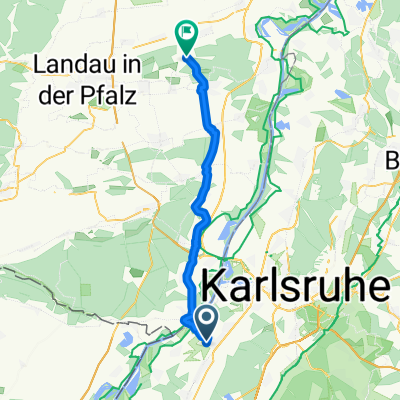
Karlsruhe -Leimersheim Fähre-Insel Rott-Hochstetten und zurück CLONED FROM ROUTE 6259
A cycling route starting in Rheinstetten, Baden-Wurttemberg, Germany.
Overview
About this route
A comfortable flat bike tour (depending on pace for young and old) main destinations: Leimersheim Ferry (beer garden with cake and coffee) Eggenstein Private Brewery - Island Rott (fish restaurant) very beautiful landscape with many resting points. Total length 35 km. The starting point can also be the Wild Park Station.
- -:--
- Duration
- 53.2 km
- Distance
- 55 m
- Ascent
- 58 m
- Descent
- ---
- Avg. speed
- ---
- Max. altitude
Route quality
Waytypes & surfaces along the route
Waytypes
Track
20.8 km
(39 %)
Path
13.3 km
(25 %)
Surfaces
Paved
36.7 km
(69 %)
Unpaved
10.1 km
(19 %)
Asphalt
35.7 km
(67 %)
Gravel
5.9 km
(11 %)
Route highlights
Points of interest along the route
Point of interest after 23 km
Restaurant Rheinblick
Continue with Bikemap
Use, edit, or download this cycling route
You would like to ride Karlsruhe -Leimersheim Fähre-Insel Rott-Hochstetten und zurück CLONED FROM ROUTE 6259 or customize it for your own trip? Here is what you can do with this Bikemap route:
Free features
- Save this route as favorite or in collections
- Copy & plan your own version of this route
- Sync your route with Garmin or Wahoo
Premium features
Free trial for 3 days, or one-time payment. More about Bikemap Premium.
- Navigate this route on iOS & Android
- Export a GPX / KML file of this route
- Create your custom printout (try it for free)
- Download this route for offline navigation
Discover more Premium features.
Get Bikemap PremiumFrom our community
Other popular routes starting in Rheinstetten
 Karlsruhe -Leimersheim Fähre-Insel Rott-Hochstetten und zurück CLONED FROM ROUTE 6259
- Distance
- 53.2 km
- Ascent
- 55 m
- Descent
- 58 m
- Location
- Rheinstetten, Baden-Wurttemberg, Germany
 Siemensstraße 2B, Rheinstetten nach Berliner Allee 20, Stutensee
- Distance
- 24 km
- Ascent
- 86 m
- Descent
- 83 m
- Location
- Rheinstetten, Baden-Wurttemberg, Germany
 Schluttenbachrunde
- Distance
- 32.6 km
- Ascent
- 290 m
- Descent
- 286 m
- Location
- Rheinstetten, Baden-Wurttemberg, Germany
 RR -Verkehrsarme " Fünf Täler Rundtour" - Rheintal, Albtal, Eyachtal, Enztal & Murgtal.
- Distance
- 104.7 km
- Ascent
- 1,027 m
- Descent
- 1,029 m
- Location
- Rheinstetten, Baden-Wurttemberg, Germany
 aus Rheinstetten in den Kraichgau mit Ortsdurchfahrten von Forchheim - KA Daxlanden - KA Knielingen - Eggenstein - Leopoldshafen - Staffort - Untergrombach - Ob
- Distance
- 112.2 km
- Ascent
- 420 m
- Descent
- 418 m
- Location
- Rheinstetten, Baden-Wurttemberg, Germany
 Rheinroute
- Distance
- 80.5 km
- Ascent
- 122 m
- Descent
- 123 m
- Location
- Rheinstetten, Baden-Wurttemberg, Germany
 KA-Flensburg
- Distance
- 1,114 km
- Ascent
- 595 m
- Descent
- 704 m
- Location
- Rheinstetten, Baden-Wurttemberg, Germany
 nach zeiskam
- Distance
- 37.3 km
- Ascent
- 146 m
- Descent
- 134 m
- Location
- Rheinstetten, Baden-Wurttemberg, Germany
Open it in the app