

Saint-Hiippolyte loop
A cycling route starting in Prévost, Quebec, Canada.
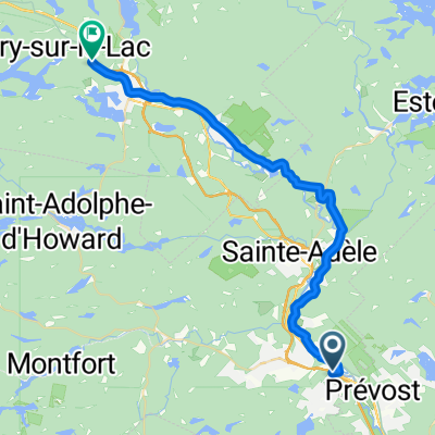
Overview
About this route
Hilly, rolling and winding, narrow guage, no shoulder, speed limit 50kph, homes along route. Bumps could be an issue on fast descents. several patches of rough ashphalt. Loop ends on a pressed-gravel bike path.
- -:--
- Duration
- 51.8 km
- Distance
- 591 m
- Ascent
- 593 m
- Descent
- ---
- Avg. speed
- ---
- Max. altitude
Route quality
Waytypes & surfaces along the route
Waytypes
Road
41.6 km
(80 %)
Cycleway
8.2 km
(16 %)
Surfaces
Paved
43.6 km
(84 %)
Unpaved
7.4 km
(14 %)
Asphalt
36 km
(69 %)
Paved (undefined)
7.6 km
(15 %)
Continue with Bikemap
Use, edit, or download this cycling route
You would like to ride Saint-Hiippolyte loop or customize it for your own trip? Here is what you can do with this Bikemap route:
Free features
- Save this route as favorite or in collections
- Copy & plan your own version of this route
- Sync your route with Garmin or Wahoo
Premium features
Free trial for 3 days, or one-time payment. More about Bikemap Premium.
- Navigate this route on iOS & Android
- Export a GPX / KML file of this route
- Create your custom printout (try it for free)
- Download this route for offline navigation
Discover more Premium features.
Get Bikemap PremiumFrom our community
Other popular routes starting in Prévost
 Prévost_Côte du Lac-de-l'Achigan_Ste-Anne-des-Lacs CLONED FROM ROUTE 1293980
- Distance
- 87.9 km
- Ascent
- 827 m
- Descent
- 698 m
- Location
- Prévost, Quebec, Canada
 2011 - Laurentides - Jour 2
- Distance
- 101 km
- Ascent
- 429 m
- Descent
- 471 m
- Location
- Prévost, Quebec, Canada
 Shawbridge - Route 370 (Ch. Pierre-Péladeau)
- Distance
- 18.7 km
- Ascent
- 194 m
- Descent
- 95 m
- Location
- Prévost, Quebec, Canada
 De Rue de la Traverse 1272, Prévost à Rue Guénette 1276, Prévost
- Distance
- 63 km
- Ascent
- 433 m
- Descent
- 396 m
- Location
- Prévost, Quebec, Canada
 Petit train du nord
- Distance
- 36.5 km
- Ascent
- 314 m
- Descent
- 169 m
- Location
- Prévost, Quebec, Canada
 ste anne des lacs, ste adèle, prévost
- Distance
- 50.2 km
- Ascent
- 707 m
- Descent
- 794 m
- Location
- Prévost, Quebec, Canada
 Route to Kingston
- Distance
- 401.6 km
- Ascent
- 1,098 m
- Descent
- 1,190 m
- Location
- Prévost, Quebec, Canada
 st-anne des lacs- pays den haut---710m CLONED FROM ROUTE 1523727
- Distance
- 63 km
- Ascent
- 599 m
- Descent
- 601 m
- Location
- Prévost, Quebec, Canada
Open it in the app