

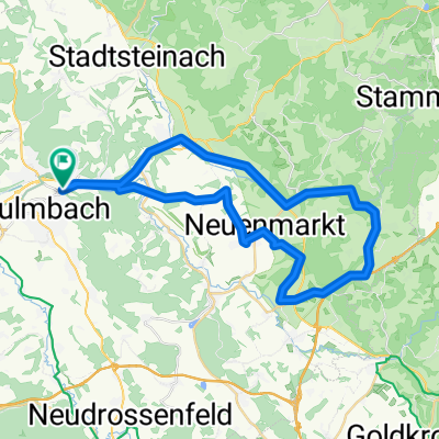
Maintalradweg Kulmbach - Bamberg
A cycling route starting in Kulmbach, Bavaria, Germany.
Overview
About this route
Kulmbach - Unterauhof - Mainleus - Willmersreuth - Schwarzach - Fassoldshof - Rothwind - Mainroth - Mainklein - Theissau - Burgkunstadt - Altenkunstadt - Strössendorf - Trebitzmühle - Burgstall - Hochstadt am Main - Schwürbitz - Michelau (German Basket Museum) - Lichtenfels - Grundfeld - Ruendorf - Schönbrunn - Bad Staffelstein - Niederau - Ebensfeld - Ebing - Rattelsdorf - Breitengüßbach - Kemmern - Hallstadt - Bamberg
Waymarking: green M
- -:--
- Duration
- 79.8 km
- Distance
- 187 m
- Ascent
- 250 m
- Descent
- ---
- Avg. speed
- ---
- Max. altitude
Route quality
Waytypes & surfaces along the route
Waytypes
Quiet road
23.1 km
(29 %)
Track
16 km
(20 %)
Surfaces
Paved
63.1 km
(79 %)
Unpaved
7.2 km
(9 %)
Asphalt
62.3 km
(78 %)
Gravel
4 km
(5 %)
Continue with Bikemap
Use, edit, or download this cycling route
You would like to ride Maintalradweg Kulmbach - Bamberg or customize it for your own trip? Here is what you can do with this Bikemap route:
Free features
- Save this route as favorite or in collections
- Copy & plan your own version of this route
- Sync your route with Garmin or Wahoo
Premium features
Free trial for 3 days, or one-time payment. More about Bikemap Premium.
- Navigate this route on iOS & Android
- Export a GPX / KML file of this route
- Create your custom printout (try it for free)
- Download this route for offline navigation
Discover more Premium features.
Get Bikemap PremiumFrom our community
Other popular routes starting in Kulmbach
 KU Maineck Weismain Stadeln KDorf Zertritt KU
- Distance
- 71.7 km
- Ascent
- 378 m
- Descent
- 372 m
- Location
- Kulmbach, Bavaria, Germany
 Am Gründlein, Kulmbach nach Kettenbrückstraße, Bamberg
- Distance
- 89 km
- Ascent
- 791 m
- Descent
- 856 m
- Location
- Kulmbach, Bavaria, Germany
 2017_05 Wickenreuth E-Bike-Tour
- Distance
- 37.3 km
- Ascent
- 443 m
- Descent
- 443 m
- Location
- Kulmbach, Bavaria, Germany
 Kulm Wirsb Himmelskron Neumarkt
- Distance
- 42.5 km
- Ascent
- 522 m
- Descent
- 522 m
- Location
- Kulmbach, Bavaria, Germany
 Von Kulmbach aus in die Fränkische Schweiz
- Distance
- 97.2 km
- Ascent
- 858 m
- Descent
- 814 m
- Location
- Kulmbach, Bavaria, Germany
 Ku BT Obernsees Hollfeld Kdorf Ku
- Distance
- 87.8 km
- Ascent
- 344 m
- Descent
- 367 m
- Location
- Kulmbach, Bavaria, Germany
 Oberlandtour
- Distance
- 54.3 km
- Ascent
- 528 m
- Descent
- 527 m
- Location
- Kulmbach, Bavaria, Germany
 Расслабленный маршрут
- Distance
- 16.1 km
- Ascent
- 199 m
- Descent
- 245 m
- Location
- Kulmbach, Bavaria, Germany
Open it in the app