Ruta Los Cenizos salida a Mendoza
A cycling route starting in Salamanca, Guanajuato, Mexico.
Overview
About this route
A demanding route due to steep and very rocky ascents at the beginning. It is recommended to do it in rainy times since the reservoirs will be fuller and in the village of Estanco, a seasonal river forms. More than half of the route is unpaved, and from the village called Estanco, it will be asphalted up to Mendoza. It can also be done in reverse, highly recommended for a good day of exercise.
- -:--
- Duration
- 52.4 km
- Distance
- 494 m
- Ascent
- 494 m
- Descent
- ---
- Avg. speed
- ---
- Max. altitude
Continue with Bikemap
Use, edit, or download this cycling route
You would like to ride Ruta Los Cenizos salida a Mendoza or customize it for your own trip? Here is what you can do with this Bikemap route:
Free features
- Save this route as favorite or in collections
- Copy & plan your own version of this route
- Sync your route with Garmin or Wahoo
Premium features
Free trial for 3 days, or one-time payment. More about Bikemap Premium.
- Navigate this route on iOS & Android
- Export a GPX / KML file of this route
- Create your custom printout (try it for free)
- Download this route for offline navigation
Discover more Premium features.
Get Bikemap PremiumFrom our community
Other popular routes starting in Salamanca
Boulevard Rinconada San Pedro, Salamanca a Calle San Ramón, Salamanca- Distance
- 2.5 km
- Ascent
- 3 m
- Descent
- 3 m
- Location
- Salamanca, Guanajuato, Mexico
J71 – Lundi 21 mars 2016 – Salamaca – Ganajuato- Distance
- 72.3 km
- Ascent
- ---
- Descent
- ---
- Location
- Salamanca, Guanajuato, Mexico
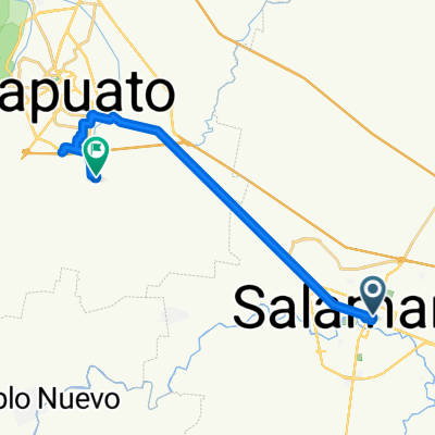
Ruta desde Calle 5 43, Salamanca- Distance
- 39.9 km
- Ascent
- 187 m
- Descent
- 170 m
- Location
- Salamanca, Guanajuato, Mexico
Ruta Los Cenizos salida a Mendoza- Distance
- 52.4 km
- Ascent
- 494 m
- Descent
- 494 m
- Location
- Salamanca, Guanajuato, Mexico
De Calle Alvaro Obregón a Calle Santo Tomas de Aquino- Distance
- 33.1 km
- Ascent
- 470 m
- Descent
- 454 m
- Location
- Salamanca, Guanajuato, Mexico
De Boulevard Faja de Oro a Calle Santo Tomas de Aquino- Distance
- 30.6 km
- Ascent
- 423 m
- Descent
- 406 m
- Location
- Salamanca, Guanajuato, Mexico
Calle San Ramón, Salamanca a Calle Estancia de Mancera Sur, Salamanca- Distance
- 3.2 km
- Ascent
- 9 m
- Descent
- 15 m
- Location
- Salamanca, Guanajuato, Mexico
Calle Estancia de Mancera Sur, Salamanca a Calle Estancia de Mancera Sur, Salamanca- Distance
- 9.3 km
- Ascent
- 70 m
- Descent
- 69 m
- Location
- Salamanca, Guanajuato, Mexico
Open it in the app

