

gute Grundlagenrunde, nur leichte, kurze Steigungen
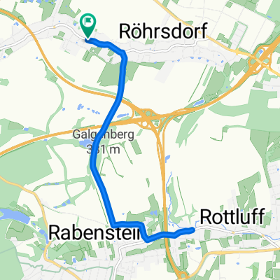
A cycling route starting in Wittgensdorf, Saxony, Germany.
Overview
About this route
Beautiful route to stay in the GL heart rate zone. Only short, gentle climbs. Very little traffic except on Chemnitztalstraße. Scenery is SUPER! Very suitable for road cycling. However, the surface on the section after the A4 up to Slevoigtstraße is lacking.
- -:--
- Duration
- 45.7 km
- Distance
- 331 m
- Ascent
- 288 m
- Descent
- ---
- Avg. speed
- 356 m
- Max. altitude
Route quality
Waytypes & surfaces along the route
Waytypes
Road
11.9 km
(26 %)
Quiet road
4.1 km
(9 %)
Surfaces
Paved
37.5 km
(82 %)
Asphalt
37.5 km
(82 %)
Undefined
8.2 km
(18 %)
Continue with Bikemap
Use, edit, or download this cycling route
You would like to ride gute Grundlagenrunde, nur leichte, kurze Steigungen or customize it for your own trip? Here is what you can do with this Bikemap route:
Free features
- Save this route as favorite or in collections
- Copy & plan your own version of this route
- Sync your route with Garmin or Wahoo
Premium features
Free trial for 3 days, or one-time payment. More about Bikemap Premium.
- Navigate this route on iOS & Android
- Export a GPX / KML file of this route
- Create your custom printout (try it for free)
- Download this route for offline navigation
Discover more Premium features.
Get Bikemap PremiumFrom our community
Other popular routes starting in Wittgensdorf
 Chemnitzumrundung RR
- Distance
- 70.8 km
- Ascent
- 669 m
- Descent
- 669 m
- Location
- Wittgensdorf, Saxony, Germany
 Leipziger Straße nach Zöllnerplatz
- Distance
- 6.4 km
- Ascent
- 14 m
- Descent
- 131 m
- Location
- Wittgensdorf, Saxony, Germany
 Dingens von Schatz
- Distance
- 10.3 km
- Ascent
- 109 m
- Descent
- 109 m
- Location
- Wittgensdorf, Saxony, Germany
 Kriebsteinrunde
- Distance
- 72.4 km
- Ascent
- 476 m
- Descent
- 476 m
- Location
- Wittgensdorf, Saxony, Germany
 2. DGT Radtour Wittgensdorf - Muldetal - Wittgensdorf
- Distance
- 47.4 km
- Ascent
- 313 m
- Descent
- 314 m
- Location
- Wittgensdorf, Saxony, Germany
 Crimmitschauer-Küchwald-Strecke (S01)
- Distance
- 6.6 km
- Ascent
- 97 m
- Descent
- 109 m
- Location
- Wittgensdorf, Saxony, Germany
 Chemnitz Tour
- Distance
- 29.8 km
- Ascent
- 232 m
- Descent
- 239 m
- Location
- Wittgensdorf, Saxony, Germany
 Kleine Chemnitztalrunde
- Distance
- 52.6 km
- Ascent
- 314 m
- Descent
- 314 m
- Location
- Wittgensdorf, Saxony, Germany
Open it in the app