Rund um den Bilster Berg
A cycling route starting in Nieheim, North Rhine-Westphalia, Germany.
Overview
About this route
The Bilster Berg can be explored not just by car on the new test track, but also widely by bike! Starting point, for example, the monument in Merlsheim, then towards Nieheim with a turn towards the test track (about 1.3 km uphill to the telegraph mast), just before the town entry, it goes on a little-trafficked country road through Pömbsen to the Park-Cafe (self-service) in Bad Hermannsborn, and then follow the bike path signage to the right towards Merlsheim through Schönenberg. Completely paved, with appropriate tires it can certainly be navigated on side roads as well. A recommended afternoon trip in beautiful landscape!
- -:--
- Duration
- 21 km
- Distance
- 326 m
- Ascent
- 323 m
- Descent
- ---
- Avg. speed
- ---
- Max. altitude
Route quality
Waytypes & surfaces along the route
Waytypes
Path
5.4 km
(26 %)
Quiet road
4 km
(19 %)
Surfaces
Paved
13.2 km
(63 %)
Unpaved
0.6 km
(3 %)
Asphalt
10.9 km
(52 %)
Paved (undefined)
2.3 km
(11 %)
Continue with Bikemap
Use, edit, or download this cycling route
You would like to ride Rund um den Bilster Berg or customize it for your own trip? Here is what you can do with this Bikemap route:
Free features
- Save this route as favorite or in collections
- Copy & plan your own version of this route
- Sync your route with Garmin or Wahoo
Premium features
Free trial for 3 days, or one-time payment. More about Bikemap Premium.
- Navigate this route on iOS & Android
- Export a GPX / KML file of this route
- Create your custom printout (try it for free)
- Download this route for offline navigation
Discover more Premium features.
Get Bikemap PremiumFrom our community
Other popular routes starting in Nieheim
- Route Um Gut Externbrock
- Distance
- 9.2 km
- Ascent
- 108 m
- Descent
- 108 m
- Location
- Nieheim, North Rhine-Westphalia, Germany
- D 501 Nieheim - HF-Laar
- Distance
- 62.7 km
- Ascent
- 268 m
- Descent
- 368 m
- Location
- Nieheim, North Rhine-Westphalia, Germany
- Eversen - Schiedersee - Hagedorn - Rolfzen - Eversen
- Distance
- 33.9 km
- Ascent
- 213 m
- Descent
- 220 m
- Location
- Nieheim, North Rhine-Westphalia, Germany
- Nieheim Norderteich
- Distance
- 42.8 km
- Ascent
- 380 m
- Descent
- 380 m
- Location
- Nieheim, North Rhine-Westphalia, Germany
- Koobenweg 2, Steinheim nach Mittelstraße 89, Horn-Bad Meinberg
- Distance
- 12.7 km
- Ascent
- 206 m
- Descent
- 162 m
- Location
- Nieheim, North Rhine-Westphalia, Germany
- Höxter
- Distance
- 53.2 km
- Ascent
- 433 m
- Descent
- 433 m
- Location
- Nieheim, North Rhine-Westphalia, Germany
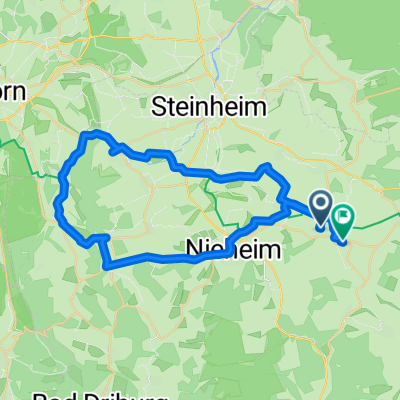
- Tag 4: Nieheim - Stadtoldendorf
- Distance
- 48.4 km
- Ascent
- 308 m
- Descent
- 282 m
- Location
- Nieheim, North Rhine-Westphalia, Germany
- Kyll - Weser Etappe 10 Nieheim - Schötmar
- Distance
- 48.7 km
- Ascent
- 177 m
- Descent
- 295 m
- Location
- Nieheim, North Rhine-Westphalia, Germany
Open it in the app